IMAGES TAKEN NEAR TO
Mill Street, CASTLEFORD, WF10 5LF
Introduction
This page details the photographs taken nearby to Mill Street, WF10 5LF by members of the Geograph project.
The Geograph project started in 2005 with the aim of publishing, organising and preserving representative images for every square kilometre of Great Britain, Ireland and the Isle of Man.

There are currently over 7.5m images from over14,400 individuals and you can help contribute to the project by visiting https://www.geograph.org.uk
Image Map
Images are licensed for reuse under creativecommons.org/licenses/by-sa/2.0
Notes
- Clicking on the map will re-center to the selected point.
- The higher the marker number, the further away the image location is from the centre of the postcode.
Image Listing (43 Images Found)
Images are licensed for reuse under creativecommons.org/licenses/by-sa/2.0
Image
Details
Distance
1
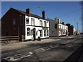
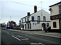
The Black Bull, Hightown
The Black Bull and The Hightown public houses on Lumley Street, Hightown, Castleford.
Image: © Ian Russell
Taken: 21 Mar 2007
0.05 miles
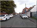
4
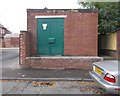
Electricity Substation No 3912 - Rhodes Street
Image: © Betty Longbottom
Taken: 17 Oct 2016
0.08 miles
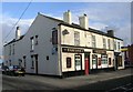
6
The Black Bull Public House, Hightown, Castleford
Image: © Bill Henderson
Taken: 26 Nov 2007
0.08 miles
8
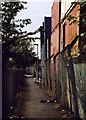
Path from Hightown to Whitwood Mere
Originally ran due north along the old Castleford-Whitwood Mere boundary line, linking the population of Whitwood Mere with their parish church http://www.geograph.org.uk/photo/372629 and school. Diverted along a west-north dog-leg, viewed here, in the 1970s when the former United Glass works expanded across its course, though by that time hardly used since most of the houses in Whitwood Mere had long been demolished.
Image: © David Pickersgill
Taken: 30 Sep 2007
0.09 miles
10
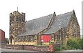
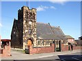
Hightown, Castleford, All Saints Church
Image: © Bill Henderson
Taken: Unknown
0.10 miles