
IMAGES TAKEN NEAR TO
Healdfield Road, CASTLEFORD, WF10 4LL
Introduction
This page details the photographs taken nearby to Healdfield Road, WF10 4LL by members of the Geograph project.
The Geograph project started in 2005 with the aim of publishing, organising and preserving representative images for every square kilometre of Great Britain, Ireland and the Isle of Man.

There are currently over 7.5m images from over14,400 individuals and you can help contribute to the project by visiting https://www.geograph.org.uk
Image Map
Images are licensed for reuse under creativecommons.org/licenses/by-sa/2.0
Notes
- Clicking on the map will re-center to the selected point.
- The higher the marker number, the further away the image location is from the centre of the postcode.
Image Listing (37 Images Found)
Images are licensed for reuse under creativecommons.org/licenses/by-sa/2.0
Image
Details
Distance
1

Castleford Cemetery
The upper part of the cemetery, on the south side of Healdfield Road from http://www.geograph.org.uk/photo/68254. Back in the 19th century, those of a Church of England persuasion were buried in this side, while Catholics, Methodists and other religions were buried on the other side of the road! The office block and chimney behind the trees belong to the Nestlé factory on Wheldon Road, which makes Yorkie bars and After Eight mints.
Image: © David Pickersgill
Taken: 9 Sep 2007
0.03 miles
2

Castleford Cemetery
Viewed from Queen's Park Castleford looking north.
Image: © derek dye
Taken: 2 Aug 2016
0.05 miles
3

Cemetery - Healdfield Road, Castleford
Looking north at the cemetery and beyond, the railway line linking Castleford with Leeds and York and the Hickson & Welch chemical works in the background.
Image: © Paul Johnston-Knight
Taken: 19 Oct 2005
0.05 miles
4
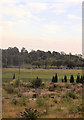
Recreation Ground Castleford
Off Healdfield road
Image: © John Firth
Taken: 18 Aug 2011
0.08 miles

6
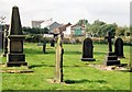
Castleford Cemetery
A corner of the northern half of the cemetery with just a few of the Victorian gravestones remaining. The obelisk on the left is a memorial to members of the Lumb family of bottlemakers, one among the many 19th century Castleford industrialists whose graves can be found here. Fawcett's maltkilns in the background.
Image: © David Pickersgill
Taken: 9 Sep 2007
0.13 miles
7

Castleford High School - Healdfield Road
Image: © Betty Longbottom
Taken: 18 Aug 2010
0.15 miles


