IMAGES TAKEN NEAR TO
Woodside Street, CASTLEFORD, WF10 2HF
Introduction
This page details the photographs taken nearby to Woodside Street, WF10 2HF by members of the Geograph project.
The Geograph project started in 2005 with the aim of publishing, organising and preserving representative images for every square kilometre of Great Britain, Ireland and the Isle of Man.

There are currently over 7.5m images from over14,400 individuals and you can help contribute to the project by visiting https://www.geograph.org.uk
Image Map
Images are licensed for reuse under creativecommons.org/licenses/by-sa/2.0
Notes
- Clicking on the map will re-center to the selected point.
- The higher the marker number, the further away the image location is from the centre of the postcode.
Image Listing (65 Images Found)
Images are licensed for reuse under creativecommons.org/licenses/by-sa/2.0
Image
Details
Distance


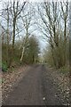
4
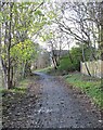
Old rail track at Woodend
Now a branch of the Lines Way system of paths and cycleways, this was originally a mineral line serving nearby coal pits such as Lowther Colliery, now long gone.
Image: © Gordon Hatton
Taken: 25 Nov 2022
0.07 miles
5
The Lines, north-east of Leeds Road
The former colliery railway line curving up to a junction with a former branch line.
Image: © Christine Johnstone
Taken: 5 Jan 2013
0.07 miles
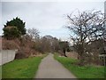
6
Lines Way near Woodside Street
The Lines Way is a cycle path from Garforth to Allerton Bywater along the former railway line. It is designated as part of National Cycle Network route 697.
Image: © DS Pugh
Taken: 18 Mar 2023
0.07 miles
7
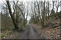
Lines Way in a cutting
The Lines Way is a cycle path from Garforth to Allerton Bywater along the former railway line. It is designated as part of National Cycle Network route 697.
Image: © DS Pugh
Taken: 18 Mar 2023
0.07 miles
9

On the Lines Way
The former Garforth to Castleford Railway trackbed heading towards the Bowers Junction.
The line beyond the junction stayed in service until the 1990's, almost exclusively concerned with the transportation of coal.
Image: © Chris Heaton
Taken: 9 May 2021
0.07 miles