
IMAGES TAKEN NEAR TO
Hunt Street, CASTLEFORD, WF10 1NS
Introduction
This page details the photographs taken nearby to Hunt Street, WF10 1NS by members of the Geograph project.
The Geograph project started in 2005 with the aim of publishing, organising and preserving representative images for every square kilometre of Great Britain, Ireland and the Isle of Man.

There are currently over 7.5m images from over14,400 individuals and you can help contribute to the project by visiting https://www.geograph.org.uk
Image Map
Images are licensed for reuse under creativecommons.org/licenses/by-sa/2.0
Notes
- Clicking on the map will re-center to the selected point.
- The higher the marker number, the further away the image location is from the centre of the postcode.
Image Listing (27 Images Found)
Images are licensed for reuse under creativecommons.org/licenses/by-sa/2.0
Image
Details
Distance
2

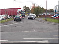
UCI Logistics, Castleford
Trailer storage yard of UCI Logistics, Methley Road. Formerly the transport section of the former United Glass works, before that the site of Hartley's pottery which closed in 1960.
Image: © David Pickersgill
Taken: 30 Sep 2007
0.08 miles
3
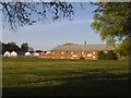
Raglan Industrial Estate, Castleford
The principal brick built building in this photo is the former Lord Raglan maltkiln Image which gave its name to the industrial estate around it.
Image: © Stephen Craven
Taken: 14 May 2019
0.08 miles
4
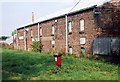
Lord Raglan maltkilns
19th century maltkilns on Methley Road, Whitwood Mere, now converted into industrial units.
Image: © David Pickersgill
Taken: 7 Oct 2007
0.10 miles
6
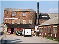
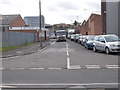
Castleford Chrome Platers
The three-storey building was a rug mill for many years and before that may have been part of the Mere Brewery during the 19th century. It is one of the oldest remaining industrial buildings in Castleford.
Image: © David Pickersgill
Taken: 7 Oct 2007
0.12 miles
8
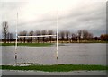
Match postponed
No play this weekend on Castleford Panthers amateur rugby league club's pitch, Methley Road.
Image: © David Pickersgill
Taken: 20 Jan 2008
0.12 miles
9
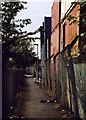
Path from Hightown to Whitwood Mere
Originally ran due north along the old Castleford-Whitwood Mere boundary line, linking the population of Whitwood Mere with their parish church http://www.geograph.org.uk/photo/372629 and school. Diverted along a west-north dog-leg, viewed here, in the 1970s when the former United Glass works expanded across its course, though by that time hardly used since most of the houses in Whitwood Mere had long been demolished.
Image: © David Pickersgill
Taken: 30 Sep 2007
0.13 miles
