IMAGES TAKEN NEAR TO
Oakridge Avenue, RADLETT, WD7 8EP
Introduction
This page details the photographs taken nearby to Oakridge Avenue, WD7 8EP by members of the Geograph project.
The Geograph project started in 2005 with the aim of publishing, organising and preserving representative images for every square kilometre of Great Britain, Ireland and the Isle of Man.

There are currently over 7.5m images from over14,400 individuals and you can help contribute to the project by visiting https://www.geograph.org.uk
Image Map
Images are licensed for reuse under creativecommons.org/licenses/by-sa/2.0
Notes
- Clicking on the map will re-center to the selected point.
- The higher the marker number, the further away the image location is from the centre of the postcode.
Image Listing (13 Images Found)
Images are licensed for reuse under creativecommons.org/licenses/by-sa/2.0
Image
Details
Distance
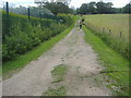
2

Public footpath with farm buildings, Radlett
Image: © David Howard
Taken: 19 Jun 2009
0.10 miles
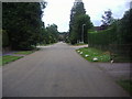
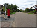
3
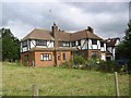
Last house in the road, Private Estate, Radlett
This is an upmarket estate but I wonder how they organise repairs to the tarmac roads.
Image: © Jack Hill
Taken: 12 Aug 2005
0.10 miles
4
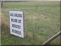
Sign at end of the upmarket estate.
Actually there is also a notice which says "No Horses"
Image: © Jack Hill
Taken: 12 Aug 2005
0.10 miles
5
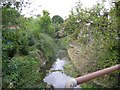
The Brook flowing under Oakridge Avenue Radlett
The brook was known as "Tykes Water" and flowed from Aldenham Reservoir to the Coln.
Image: © Jack Hill
Taken: 12 Aug 2005
0.13 miles
6
Public footpath behind houses in Radlett
Image: © David Howard
Taken: 19 Jun 2009
0.19 miles
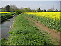
7
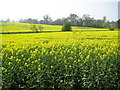
Radlett: Oil seed rape in the valley of Radlett Brook
Radlett Brook runs in the dip marked with a straight green line between two fields of oil seed rape.
Image: © Nigel Cox
Taken: 15 Apr 2009
0.22 miles
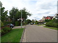
9
Oakridge Avenue, Radlett
Showing position of Postbox No. WD7 179.
See Image] for context.
Image: © JThomas
Taken: 3 Aug 2019
0.23 miles
10
Radlett Brook
Radlett Brook is a tributary of the River Colne and is seen here looking downstream between fields of oil seed rape.
This is the green band seen in Image
Image: © Nigel Cox
Taken: 15 Apr 2009
0.24 miles