IMAGES TAKEN NEAR TO
Watling Street, RADLETT, WD7 7HS
Introduction
This page details the photographs taken nearby to Watling Street, WD7 7HS by members of the Geograph project.
The Geograph project started in 2005 with the aim of publishing, organising and preserving representative images for every square kilometre of Great Britain, Ireland and the Isle of Man.

There are currently over 7.5m images from over14,400 individuals and you can help contribute to the project by visiting https://www.geograph.org.uk
Image Map
Images are licensed for reuse under creativecommons.org/licenses/by-sa/2.0
Notes
- Clicking on the map will re-center to the selected point.
- The higher the marker number, the further away the image location is from the centre of the postcode.
Image Listing (11 Images Found)
Images are licensed for reuse under creativecommons.org/licenses/by-sa/2.0
Image
Details
Distance
1
Ex Black Horse Pub, Colney Street
This pile of bricks has been lying here for a couple of years and a sign says that John and Jean are mine hosts. Strange.
They also had karaoke nights.
Image: © Jack Hill
Taken: 12 Aug 2005
0.05 miles
2

Business premises on Watling Street, Colney Street
This development has taken the place of an unwanted
petrol station. The business is said to be asset management and sports management.
Image: © Jack Hill
Taken: 12 Aug 2005
0.05 miles
5
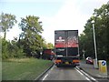
Lorries turning into Harper Lane from Watling Street
They had just come out of the industrial estate and had a hard time doing the turn but managed it in the end.
Image: © David Howard
Taken: 22 Jul 2014
0.18 miles
6
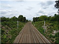
Midland Main Line, Radlett
Northbound view from the bridge on the B556.
Image: © JThomas
Taken: 3 Aug 2019
0.19 miles
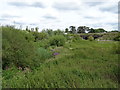
7
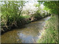
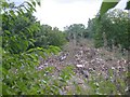
Radlett Brook
Radlett Brook is a tributary of the River Colne and is viewed here looking downstream, about 600 metres away from its confluence with the Colne.
Image: © Nigel Cox
Taken: 15 Apr 2009
0.21 miles
8
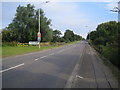
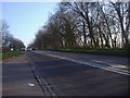
Colney Street: Watling Street
This is now the A5183 Radlett Road, but used to be the A5 Watling Street, at the southern approach to Colney Street. Just beyond the Colney Street road sign is Colneystreet Bridge which carries the road over the River Colne.
Image: © Nigel Cox
Taken: 12 Aug 2007
0.22 miles
9
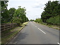
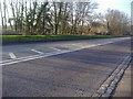
Radlett Road (A5183)
On the Colneystreet Bridge over the River Colne.
Image: © JThomas
Taken: 3 Aug 2019
0.24 miles
10
The River Colne, Colney Street
View towards the bridge carrying the Midland Mainline Railway.
Image: © JThomas
Taken: 3 Aug 2019
0.24 miles