IMAGES TAKEN NEAR TO
Buckettsland Lane, BOREHAMWOOD, WD6 5PS
Introduction
This page details the photographs taken nearby to Buckettsland Lane, WD6 5PS by members of the Geograph project.
The Geograph project started in 2005 with the aim of publishing, organising and preserving representative images for every square kilometre of Great Britain, Ireland and the Isle of Man.

There are currently over 7.5m images from over14,400 individuals and you can help contribute to the project by visiting https://www.geograph.org.uk
Image Map
Images are licensed for reuse under creativecommons.org/licenses/by-sa/2.0
Notes
- Clicking on the map will re-center to the selected point.
- The higher the marker number, the further away the image location is from the centre of the postcode.
Image Listing (9 Images Found)
Images are licensed for reuse under creativecommons.org/licenses/by-sa/2.0
Image
Details
Distance
3
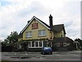
Pub in Well End
Mops and Brooms seems a strange name. I wonder what it was called originally.
Image: © Jack Hill
Taken: 7 Jul 2005
0.12 miles
4
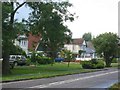
Houses in Well End
Not sufficient houses to keep the pub in business so hooray for cars.
Image: © Jack Hill
Taken: 7 Jul 2005
0.12 miles
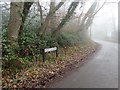
5
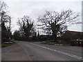
High Canons at the junction with Buckettsland Lane
Image: © David Howard
Taken: 20 Mar 2014
0.16 miles
6
Junction of Potters Lane and Well End Road
Image: © David Howard
Taken: 9 Dec 2011
0.16 miles
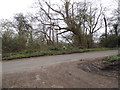
7
High Canons/Buckettsland Lane junction
Image: © Neil Theasby
Taken: 17 Dec 2016
0.17 miles
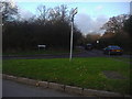
8
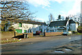
Hedging and Tree Growers Entrance
At Well End, Boreham Wood, the "Folia" group supplies trees and hedging to a wide range of customers.
Image: © Neil Theasby
Taken: 17 Dec 2016
0.18 miles
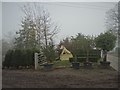
9

Well End: High Canons
High Canons is both the name of this lane and the large house whose grounds are off to the right.
Image: © Nigel Cox
Taken: 17 Jul 2008
0.25 miles