IMAGES TAKEN NEAR TO
Stanborough Avenue, BOREHAMWOOD, WD6 5LX
Introduction
This page details the photographs taken nearby to Stanborough Avenue, WD6 5LX by members of the Geograph project.
The Geograph project started in 2005 with the aim of publishing, organising and preserving representative images for every square kilometre of Great Britain, Ireland and the Isle of Man.

There are currently over 7.5m images from over14,400 individuals and you can help contribute to the project by visiting https://www.geograph.org.uk
Image Map (Loading...)


Getting Data...Please wait
Leaflet Map data © OpenStreetMap
Images are licensed for reuse under creativecommons.org/licenses/by-sa/2.0
Notes
- Clicking on the map will re-center to the selected point.
- The higher the marker number, the further away the image location is from the centre of the postcode.
Image Listing (7 Images Found)
Images are licensed for reuse under creativecommons.org/licenses/by-sa/2.0
Image
Details
Distance
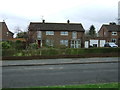
4
House on Gateshead Road
Looking up Cowley Hill.
Image: © Robin Webster
Taken: 2 Dec 2012
0.20 miles
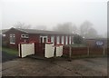
5
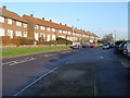
Borehamwood: Gateshead Road
Post-war housing estate, viewed looking eastwards from east of the junction with Aycliffe Road.
Image: © Nigel Cox
Taken: 10 Dec 2005
0.21 miles
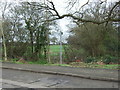
6
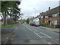
Cowley Hill, Green Street
Looking north west.
Image: © JThomas
Taken: 18 Mar 2017
0.23 miles
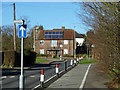
7
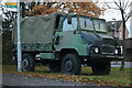
Old military lorry on Green Street, Borehamwood
Image: © David Howard
Taken: 15 Nov 2020
0.25 miles