IMAGES TAKEN NEAR TO
The Reddings, Red Road, BOREHAMWOOD, WD6 4SS
Introduction
This page details the photographs taken nearby to The Reddings, Red Road, WD6 4SS by members of the Geograph project.
The Geograph project started in 2005 with the aim of publishing, organising and preserving representative images for every square kilometre of Great Britain, Ireland and the Isle of Man.

There are currently over 7.5m images from over14,400 individuals and you can help contribute to the project by visiting https://www.geograph.org.uk
Image Map
Images are licensed for reuse under creativecommons.org/licenses/by-sa/2.0
Notes
- Clicking on the map will re-center to the selected point.
- The higher the marker number, the further away the image location is from the centre of the postcode.
Image Listing (21 Images Found)
Images are licensed for reuse under creativecommons.org/licenses/by-sa/2.0
Image
Details
Distance
1
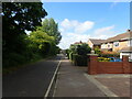
Theobald Street, Borehamwood
The main part of Theobald Street runs parallel to this service road on the other side of the trees on the left
Image: © Marathon
Taken: 25 May 2022
0.02 miles
2
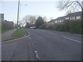
Theobald Street, Borehamwood
Red Lodge is on the right
Image: © David Howard
Taken: 9 Dec 2011
0.07 miles
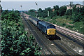
3
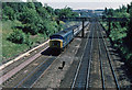
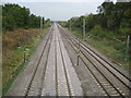
Footbridge and Express
A northbound express passes under a lattice girder footbridge on the midland line, north of Elstree. I'm not sure why the express is using the slow lines. The line has been electrified since this photo was taken and the footbridge has been removed.
Image: © Martin Addison
Taken: Unknown
0.09 miles
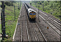
4
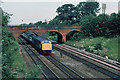
Bridge Over The Midland Mainline
A class 45 bursts under the bridge with a St. Pancras bound express. When the line was electrified the footbridge from which this photo was taken was removed. All footpaths now use the brick bridge in the photo. Note the twin telegraph poles on the right of the line - once a common sight along our railway network, now largely gone. Note also the tall signals beyond the bridge. Each post carries two signal arms (only the top ones are visible here) so that the drivers can see the aspect of the signal from this side of the bridge and when they have passed under it.
Image: © Martin Addison
Taken: Unknown
0.09 miles
5
Borehamwood: Midland mainline railway
Thirty years after Martin's Image and the scenery and the train have changed quite markedly. As Martin says the footbridge has gone and the electrification infrastructure has been in place for many years now. Here a northbound East Midlands express train has just passed through Elstree & Borehamwood station and is hurtling towards the Red Road bridge.
And for them that needs to know such things the unit number is 222018.
Image: © Nigel Cox
Taken: 14 Oct 2009
0.09 miles
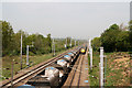
6
Empty Hopper Train
A class 66 diesel locomotive brings a train of empty aggregates hoppers north through the outskirts of Borehamwood. Elstree & Borehamwood station is behind the bridge in the distance.
Image: © Martin Addison
Taken: 21 Apr 2011
0.10 miles
7
Passing Trains
A southbound stopping service in the form of a class 319 electric multiple unit pass a northbound train of empty Bardon Aggregates hoppers on the outskirts of Boreham wood.
Image: © Martin Addison
Taken: 21 Apr 2011
0.11 miles
8
Southbound Parcels
A class 45 heads a train of three BG's (Guards Brake carriages) towards Elstree. Behind are special tall semaphores with repeating arms. They are arranged so that the northbound drivers can see the aspect of the signal from the other side of the bridge that this photo is taken from. Being so tall, the signals have bracing wires to the white posts on the embankment on the right and to another set of posts on the left that are hidden by the vegetation. The signal between the tracks uses the standard Midland Railway circular post. However, the one to the left of the tracks is of a lattice design - see Image for a closer view.
Image: © Martin Addison
Taken: Unknown
0.11 miles
9
Borehamwood: Midland mainline railway
This is another near repeat of one of Martin's images from 1979, this time Image, viewed from the Red Road bridge. The modern gantry seen in Martin's photo that was to carry the new electric signals which were replacing the old semaphore signals and were about to be commissioned in 1979 has long since itself disappeared from the scene.
The up fast line has recently been re-ballasted. Just visible in the bottom of the photograph between the two fast lines, with a metal mesh cover over it, is a drainage catch pit. These pits have sumps that are designed to capture solid material that gets into the drainage system and will be periodically emptied.
This photograph is taken from the bridge off Red Road, visible in another of Martin's images Image This is quite a massive structure the purpose of which is no longer clear. It was certainly present when the Ordnance Survey mapped the area in 1871, so it was quite probably part of the fabric of the original Midland Railway line. It has never carried a public road so maybe it was an accommodation bridge to allow the farmers at the former Tilehouse Farm to the east of the railway access to the fields to the west of it.
Image: © Nigel Cox
Taken: 14 Oct 2009
0.12 miles
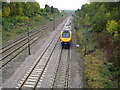
10
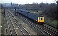
Midland Main line before electrification
A St Pancras to Bedford dmu just north of Elstree station in the days before the line was electified and the old style signals were still in place.There were two bridges sthat crossed the line just north of the station in those days.Now overhead wires spoil the view.
Image: © roger geach
Taken: Unknown
0.12 miles