IMAGES TAKEN NEAR TO
Anthony Road, BOREHAMWOOD, WD6 4NF
Introduction
This page details the photographs taken nearby to Anthony Road, WD6 4NF by members of the Geograph project.
The Geograph project started in 2005 with the aim of publishing, organising and preserving representative images for every square kilometre of Great Britain, Ireland and the Isle of Man.

There are currently over 7.5m images from over14,400 individuals and you can help contribute to the project by visiting https://www.geograph.org.uk
Image Map (Loading...)


Getting Data...Please wait
Leaflet Map data © OpenStreetMap
Images are licensed for reuse under creativecommons.org/licenses/by-sa/2.0
Notes
- Clicking on the map will re-center to the selected point.
- The higher the marker number, the further away the image location is from the centre of the postcode.
Image Listing (17 Images Found)
Images are licensed for reuse under creativecommons.org/licenses/by-sa/2.0
Image
Details
Distance

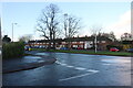
3
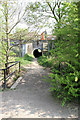
Tunnel Under The Railway
A footpath connects the open parkland and the Watling Chase Trail to the west of the Midland Main Line with Beechfield Close and the housing estates of Borehamwood to the east. A track worker and his lookout can be seen crossing over the tunnel on the railway tracks above. The bridge in the foreground crosses a drainage watercourse which probably connects to Tykes Water.
Image: © Martin Addison
Taken: 21 Apr 2011
0.10 miles
4
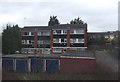
Flats on Anthony Road from Theobald Street
Image: © David Howard
Taken: 9 Dec 2011
0.10 miles
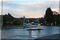
5
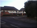
Mini-roundabout on Theobald Street
At junction of Gateshead Road and Anthony Road
Image: © David Howard
Taken: 9 Dec 2011
0.10 miles
6
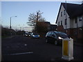
Theobald Street at the junction of Anthony Road
Image: © David Howard
Taken: 15 Nov 2020
0.10 miles
7

Watercourse Beside The Railway
Draining the area of Watling Chase to the west of the railway at Borehamwood, the water will probably drain into Tykes Water to the north.
Image: © Martin Addison
Taken: 21 Apr 2011
0.11 miles
8
Gateshead Road at the junction of Theobald Street
Image: © David Howard
Taken: 15 Nov 2020
0.11 miles
9
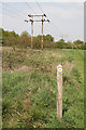
Pylons and Footpath Marker
Beside the Watling Chase Timberland Trail, these low voltage powerlines parallel the Midland Main Line from an electricity substation to the western outskirts of Borehamwood. The footpath marker in the foreground indicates a path leading across Watling Chase onto Elstree Golf Course and its clubhouse.
Image: © Martin Addison
Taken: 21 Apr 2011
0.12 miles
10
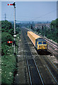
London's Waste - Return Working
A class 56 approaches Elstree with a train of empty refuse containers. The 56's had only recently started to appear on these trains in 1979.
The signal on the left has two arms and is very tall in order to provide northbound train drivers with a sight of the signal's aspect from behind the bridge that this photo is taken from. It is a little unusual in being of lattice construction, signals on the line were usually of the circular pole variety. I am advised by John Webb that the lattice type was used for tall signals as they had lower wind resistance than the circular post type. The gantries that will carry the colour light signals to replace these semaphores are already in place further along the line.
Image: © Martin Addison
Taken: Unknown
0.13 miles