IMAGES TAKEN NEAR TO
Barnet Lane, BOREHAMWOOD, WD6 3RD
Introduction
This page details the photographs taken nearby to Barnet Lane, WD6 3RD by members of the Geograph project.
The Geograph project started in 2005 with the aim of publishing, organising and preserving representative images for every square kilometre of Great Britain, Ireland and the Isle of Man.

There are currently over 7.5m images from over14,400 individuals and you can help contribute to the project by visiting https://www.geograph.org.uk
Image Map (Loading...)


Getting Data...Please wait
Leaflet Map data © OpenStreetMap
Images are licensed for reuse under creativecommons.org/licenses/by-sa/2.0
Notes
- Clicking on the map will re-center to the selected point.
- The higher the marker number, the further away the image location is from the centre of the postcode.
Image Listing (8 Images Found)
Images are licensed for reuse under creativecommons.org/licenses/by-sa/2.0
Image
Details
Distance
1
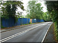
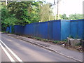
Blue hoarding on Barnet Lane
This surrounds a large plot, with no sign of activity inside, as far as can be seen (which isn't much). It was remarked in 2012 that "this development seems to be going ahead", but then, as now, the hoarding looked rather old with little if anything going on. See Image .
Image: © Robin Webster
Taken: 14 Jun 2015
0.04 miles
2
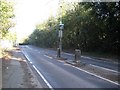
Elstree: A411 Barnet Lane
This somewhat neglected and dirty traffic island on the A411 Barnet Lane is presumably intended to mark the start of the lane separation at the approach to the Edgwarebury Lane junction behind the photographer, but curiously has a Belisha Beacon to illuminate it rather than a lamp post.
Image: © Nigel Cox
Taken: 7 Mar 2015
0.08 miles
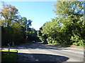
3
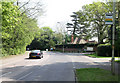
Barnet Lane
The A411 seen at the junction with Edgwarebury Lane.
Image: © Martin Addison
Taken: 21 Apr 2011
0.12 miles
4
Entrance to the Edgwarebury Hotel, Edgware
The London border runs along Barnet Lane just seen on the right, the south side here is in Edgware.
Image: © David Howard
Taken: 28 Oct 2011
0.13 miles
5
Hoardings surrounding new development
The development seems to be going ahead despite the local protest about it.
Image: © Bikeboy
Taken: 23 Jun 2012
0.14 miles
6
Barnet Lane
This is the very busy Barnet Lane seen from the junction with Edgwarebury Lane.
Image: © Marathon
Taken: 26 Sep 2018
0.15 miles
7
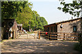
Penniwells Farm
Part of Penniwells Farm, this section is a riding school for disabled people.
Image: © Martin Addison
Taken: 21 Apr 2011
0.20 miles
8
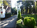
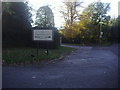
Entrance to The Manor from Edgwarebury Lane
Edgwarebury Lane is a classic example of how the Green Belt works. It leads from Barnet Lane southwards towards either the Broadfields Estate at Edgware or the A41 at Edgware Way. It seems like real unspoilt countryside. This view is just after leaving Barnet Way and is the entrance to the Laura Ashley Hotel at The Manor.
Image: © Marathon
Taken: 26 Sep 2018
0.23 miles