IMAGES TAKEN NEAR TO
Furzehill Road, BOREHAMWOOD, WD6 2DJ
Introduction
This page details the photographs taken nearby to Furzehill Road, WD6 2DJ by members of the Geograph project.
The Geograph project started in 2005 with the aim of publishing, organising and preserving representative images for every square kilometre of Great Britain, Ireland and the Isle of Man.

There are currently over 7.5m images from over14,400 individuals and you can help contribute to the project by visiting https://www.geograph.org.uk
Image Map (Loading...)


Getting Data...Please wait
Leaflet Map data © OpenStreetMap
Images are licensed for reuse under creativecommons.org/licenses/by-sa/2.0
Notes
- Clicking on the map will re-center to the selected point.
- The higher the marker number, the further away the image location is from the centre of the postcode.
Image Listing (29 Images Found)
Images are licensed for reuse under creativecommons.org/licenses/by-sa/2.0
Image
Details
Distance
2
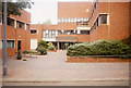
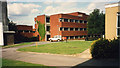
The Fire Research Station (11)
Entrance to the Clarke Building complex. On the left on the ground floor was the FRS computing section, above it the Library. On the right the offices and smaller laboratories. Straight ahead the main entrance and above it a large plant room.
Image: © John Webb
Taken: Unknown
0.19 miles
3
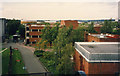
The Fire Research Station (9)
View of the Eastern side of the Fire Research Station Site, developed and bought into use in 1978. On the right nearest the camera is the end of the Lecture Theatre, just beyond that is the Publicity/AV/Photography building, and across the centre lies the Clarke building, the major offices and laboratory complex and named after a former Director. The area nearest the camera was part of a private sports ground, the area beyond the Clarke building disused allotments. Beyond the site left of centre is one of the gasholders in Station Road and on the distant far right is Borehamwood's only tower block. Closer views of the Clarke building at Image and Image
The East arm of the present Coleridge Way follows roughly the line of the site road.
Image: © John Webb
Taken: Unknown
0.20 miles
4
The Fire Research Station (10)
The Clarke building complex seen from the west. Contained numerous special laboratories, offices, the FRS Library, computing facilities and stores. Opened 1978.
Image: © John Webb
Taken: Unknown
0.20 miles
5
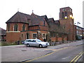
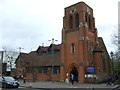
Borehamwood: All Saints Church
Construction of this Church in Shenley Road began around 1900, when Borehamwood was only a small hamlet. The Church was completed and consecrated in 1910. Its website is here http://saintnicholas.members.beeb.net/as/index.html
(Note that the parked Mercedes car was being used by someone undertaking a council traffic survey)
Image: © Nigel Cox
Taken: 29 Mar 2007
0.21 miles
6
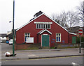
Borehamwood: Village Hall
Looking just a little in need of a coat of paint, this is Borehamwood's Village Hall, built in 1920, on Shenley Road.
Image: © Nigel Cox
Taken: 29 Mar 2007
0.21 miles
7

Borehamwood: Gate Studios from Station Road
Image: © Andy Frary
Taken: 26 Dec 2004
0.21 miles
8
The Fire Research Station (12)
A view from the North end of the site looking South-West. The brick wall running left to right of centre is the back of a number of specialist store rooms where hazardous items were kept away from other buildings. On the right of the picture is the original 1935 Furnace Building with a smaller 1970s extension added on.
This area now forms part of Shelley Close and Shakespeare Drive.
Image: © John Webb
Taken: Unknown
0.22 miles
9

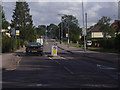
Borehamwood: Gasometers
Much of the area to the south of the railway station has been redeveloped for housing in recent years and the gasworks site seems destined to follow. The larger gas holder in the distance has a diameter of about 30 metres, while the nearer one is smaller with a diameter of about 20 metres. The road is, unsurprisingly, Station Road.
Image: © Nigel Cox
Taken: 7 Mar 2015
0.22 miles