IMAGES TAKEN NEAR TO
Station Road, BOREHAMWOOD, WD6 1DF
Introduction
This page details the photographs taken nearby to Station Road, WD6 1DF by members of the Geograph project.
The Geograph project started in 2005 with the aim of publishing, organising and preserving representative images for every square kilometre of Great Britain, Ireland and the Isle of Man.

There are currently over 7.5m images from over14,400 individuals and you can help contribute to the project by visiting https://www.geograph.org.uk
Image Map
Images are licensed for reuse under creativecommons.org/licenses/by-sa/2.0
Notes
- Clicking on the map will re-center to the selected point.
- The higher the marker number, the further away the image location is from the centre of the postcode.
Image Listing (71 Images Found)
Images are licensed for reuse under creativecommons.org/licenses/by-sa/2.0
Image
Details
Distance
1

Borehamwood: Gate Studios from Station Road
Image: © Andy Frary
Taken: 26 Dec 2004
0.03 miles
2
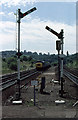
Approaching Elstree & Boreham Wood
Bracketed by semaphore signals, a class 45 diesel locomotive approaches the station at speed with a fast passenger service from St. Pancras. It has just exited the tunnels that carry the line under Deacons Hill and Scratchwood. The semaphore signals are in their last months of service (in 1979) as they are to be replaced with colour light signalling - one of which is visible with the white X denoting that it is not in use. John Webb informs me that the buildings at the top of the embankment on the left belonged to the Fire Research Station. The site now has houses on it.
Image: © Martin Addison
Taken: Unknown
0.03 miles
3

Borehamwood: Gasometers
Much of the area to the south of the railway station has been redeveloped for housing in recent years and the gasworks site seems destined to follow. The larger gas holder in the distance has a diameter of about 30 metres, while the nearer one is smaller with a diameter of about 20 metres. The road is, unsurprisingly, Station Road.
Image: © Nigel Cox
Taken: 7 Mar 2015
0.04 miles
4
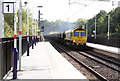
Aggregates Through Elstree
Freightliner Class 66 (66613) brings a train of empty aggregates hoppers up the climb into Elstree & Borehamwood station. Assuming it's running to time, I believe this train is the 6M54 from Thorney Mill to Bardon Hill Quarry.
Image: © Martin Addison
Taken: 16 Oct 2012
0.05 miles
5
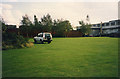
The Fire Research Station (12)
A view from the North end of the site looking South-West. The brick wall running left to right of centre is the back of a number of specialist store rooms where hazardous items were kept away from other buildings. On the right of the picture is the original 1935 Furnace Building with a smaller 1970s extension added on.
This area now forms part of Shelley Close and Shakespeare Drive.
Image: © John Webb
Taken: Unknown
0.05 miles
6
Elstree Station
A southbound train pulls into Elstree station. In the distance can be picked out the northern portals of the railway tunnels under Deacons Hill Image
Image: © David Squire
Taken: 13 Dec 2005
0.08 miles
7
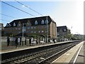
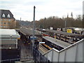
Elstree & Borehamwood railway station
Elstree & Borehamwood is a railway station on the "Thameslink" route between London, St. Albans and Bedford. It is served by suburban trains. The railway is electrified using overhead cables.
This image was taken on a bright and sunny early November day. At this time of year, the sun is low in the sky therefore shadows were long.
Image: © Malc McDonald
Taken: 4 Nov 2022
0.08 miles
8

Elstree and Borehamwood Railway Station
Image: © Stacey Harris
Taken: 28 Feb 2009
0.08 miles
9
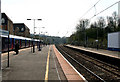
Elstree & Borehamwood station
Looking south.
Image: © Dr Neil Clifton
Taken: 15 Apr 2010
0.10 miles
10

The Station Forecourt
Elstree and Borehamwood Station, in spite of having a very long name, is rather a dull building so here is a view the other way featuring some colourful bus stops.
Image: © Des Blenkinsopp
Taken: 25 May 2011
0.10 miles