IMAGES TAKEN NEAR TO
Sergehill Lane, ABBOTS LANGLEY, WD5 0RY
Introduction
This page details the photographs taken nearby to Sergehill Lane, WD5 0RY by members of the Geograph project.
The Geograph project started in 2005 with the aim of publishing, organising and preserving representative images for every square kilometre of Great Britain, Ireland and the Isle of Man.

There are currently over 7.5m images from over14,400 individuals and you can help contribute to the project by visiting https://www.geograph.org.uk
Image Map (Loading...)


Getting Data...Please wait
Leaflet Map data © OpenStreetMap
Images are licensed for reuse under creativecommons.org/licenses/by-sa/2.0
Notes
- Clicking on the map will re-center to the selected point.
- The higher the marker number, the further away the image location is from the centre of the postcode.
Image Listing (6 Images Found)
Images are licensed for reuse under creativecommons.org/licenses/by-sa/2.0
Image
Details
Distance
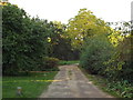
2
Gravel track to Serge Hill
In the crook of the M1 and the M25
Image: © Bikeboy
Taken: 1 Feb 2014
0.04 miles
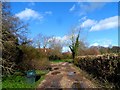
3
Sergehill Lane, Sergehill, near St Albans
Sergehill Lane at Sergehill, in Hertfordshire countryside near St Albans.
Image: © Malc McDonald
Taken: 26 Sep 2015
0.05 miles
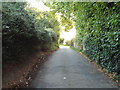
5
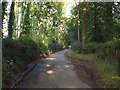
Sergehill Lane, near Bedmond
Sergehill Lane passing through woodland near Bedmond in Hertfordshire.
Image: © Malc McDonald
Taken: 26 Sep 2015
0.16 miles
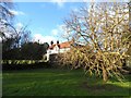
6
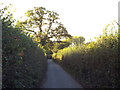
Whitehouse Lane, Sergehill, near St. Albans
Whitehouse Lane passing through Hertfordshire countryside to the south west of St. Alban's. This image was taken late on a September afternoon, as shadows were lengthening.
Image: © Malc McDonald
Taken: 26 Sep 2015
0.17 miles