IMAGES TAKEN NEAR TO
Queens Drive, ABBOTS LANGLEY, WD5 0NQ
Introduction
This page details the photographs taken nearby to Queens Drive, WD5 0NQ by members of the Geograph project.
The Geograph project started in 2005 with the aim of publishing, organising and preserving representative images for every square kilometre of Great Britain, Ireland and the Isle of Man.

There are currently over 7.5m images from over14,400 individuals and you can help contribute to the project by visiting https://www.geograph.org.uk
Image Map (Loading...)


Getting Data...Please wait
Leaflet Map data © OpenStreetMap
Images are licensed for reuse under creativecommons.org/licenses/by-sa/2.0
Notes
- Clicking on the map will re-center to the selected point.
- The higher the marker number, the further away the image location is from the centre of the postcode.
Image Listing (7 Images Found)
Images are licensed for reuse under creativecommons.org/licenses/by-sa/2.0
Image
Details
Distance
1
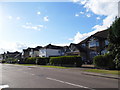
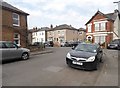
Trowley Rise, Abbots Langley
You will find roads almost the same as this from around Hayes in the south all the way to the end of Watford around here.
Image: © David Howard
Taken: 19 Sep 2012
0.12 miles
2
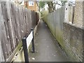
Path from Marlin Square to Tibbs Hill Road
Image: © David Howard
Taken: 16 Apr 2015
0.18 miles
3
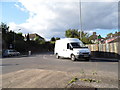
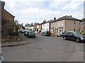
The junction of College Road and Tibbs Hill Road
Image: © David Howard
Taken: 19 Sep 2012
0.18 miles
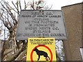
7
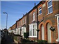
Abbots Langley: Marlin Square
This is a terrace of fine late Victorian houses. The stone plaque above the arched front door entrances in the nearest house reads "Hunscott Villas 1898".
Image: © Nigel Cox
Taken: 5 Nov 2006
0.23 miles