IMAGES TAKEN NEAR TO
South Way, ABBOTS LANGLEY, WD5 0GZ
Introduction
This page details the photographs taken nearby to South Way, WD5 0GZ by members of the Geograph project.
The Geograph project started in 2005 with the aim of publishing, organising and preserving representative images for every square kilometre of Great Britain, Ireland and the Isle of Man.

There are currently over 7.5m images from over14,400 individuals and you can help contribute to the project by visiting https://www.geograph.org.uk
Image Map (Loading...)


Getting Data...Please wait
Leaflet Map data © OpenStreetMap
Images are licensed for reuse under creativecommons.org/licenses/by-sa/2.0
Notes
- Clicking on the map will re-center to the selected point.
- The higher the marker number, the further away the image location is from the centre of the postcode.
Image Listing (4 Images Found)
Images are licensed for reuse under creativecommons.org/licenses/by-sa/2.0
Image
Details
Distance
1
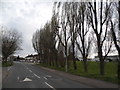
Furtherfield at the junction of South Way
Image: © David Howard
Taken: 19 Sep 2012
0.15 miles
2
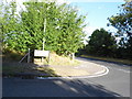
South Way at the junction of Langley Lane, Woodside
Image: © David Howard
Taken: 19 Sep 2012
0.18 miles
3
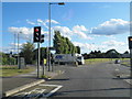
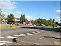
Langley Lane at the junction of Hill Farm Avenue
Straight ahead the new road was built through the old Leavesden Aerodrome and is now mainly occupied by the Warner Brothers film studio.
Image: © David Howard
Taken: 19 Sep 2012
0.18 miles