IMAGES TAKEN NEAR TO
Redwing Grove, ABBOTS LANGLEY, WD5 0GJ
Introduction
This page details the photographs taken nearby to Redwing Grove, WD5 0GJ by members of the Geograph project.
The Geograph project started in 2005 with the aim of publishing, organising and preserving representative images for every square kilometre of Great Britain, Ireland and the Isle of Man.

There are currently over 7.5m images from over14,400 individuals and you can help contribute to the project by visiting https://www.geograph.org.uk
Image Map
Images are licensed for reuse under creativecommons.org/licenses/by-sa/2.0
Notes
- Clicking on the map will re-center to the selected point.
- The higher the marker number, the further away the image location is from the centre of the postcode.
Image Listing (4 Images Found)
Images are licensed for reuse under creativecommons.org/licenses/by-sa/2.0
Image
Details
Distance
1
The junction of College Road and Tibbs Hill Road
Image: © David Howard
Taken: 19 Sep 2012
0.20 miles
4
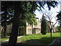
Leavesden Court, Woodside
These buildings were the front face of the hospital
Image: © Jack Hill
Taken: 15 Aug 2005
0.24 miles