IMAGES TAKEN NEAR TO
Tibbs Hill Road, ABBOTS LANGLEY, WD5 0DU
Introduction
This page details the photographs taken nearby to Tibbs Hill Road, WD5 0DU by members of the Geograph project.
The Geograph project started in 2005 with the aim of publishing, organising and preserving representative images for every square kilometre of Great Britain, Ireland and the Isle of Man.

There are currently over 7.5m images from over14,400 individuals and you can help contribute to the project by visiting https://www.geograph.org.uk
Image Map
Images are licensed for reuse under creativecommons.org/licenses/by-sa/2.0
Notes
- Clicking on the map will re-center to the selected point.
- The higher the marker number, the further away the image location is from the centre of the postcode.
Image Listing (60 Images Found)
Images are licensed for reuse under creativecommons.org/licenses/by-sa/2.0
Image
Details
Distance
1
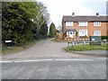
Tibbs Hill Road at the junction of Love Lane
Image: © David Howard
Taken: 16 Apr 2015
0.03 miles
2
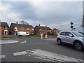
Tibbs Hill Road at the junction of High Street, Abbots Langley
Image: © David Howard
Taken: 16 Apr 2015
0.03 miles

4

Abbots Langley: Dairy Way electricity sub-station
The building on the left houses the electricity sub-station for the properties on the former Ovaltine Model Dairy Farm, now converted to residences and known as Antoinette Court, and has been built in a suitably rustic style to accord with the general design, although without a thatched roof!
Image: © Nigel Cox
Taken: 1 Feb 2008
0.09 miles
5

Log Circle
This is the Forest School log circle at Abbots Langley School
Image: © Emma Hill
Taken: 1 Feb 2016
0.11 miles
6
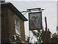
The Boys Home Pub Abbots Langley
A strange name for a pub but probably the original one.
Image: © Jack Hill
Taken: 18 Aug 2005
0.13 miles
7

R.C Church in Abbots Langley
The huge bas relief panel over the entrance gives it prominence when seen from the High Street.
Image: © Jack Hill
Taken: 18 Aug 2005
0.14 miles
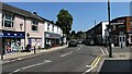
8

The Library at Abbots Langley
This building has a very friendly air about it and floods of light inside from a top level rooflight
Image: © Jack Hill
Taken: 18 Aug 2005
0.14 miles
10

Abbots Langley: Former Ovaltine Model Dairy Farm
The farm, on Bedmond Road, dates from 1932, but was closed in 1979. The main entrance to the farm was through the arch in the middle of this building. This leads to a cluster of similar thatched buildings. Since 1982 all of these have been converted to residential properties now under the collective name of Antoinette Court. The origin of this name is that the farm was designed as a replica of one built by King Louis XVI of France for Queen Marie Antoinette.
Image: © Nigel Cox
Taken: 1 Feb 2008
0.14 miles