IMAGES TAKEN NEAR TO
Hazelbury Avenue, ABBOTS LANGLEY, WD5 0DF
Introduction
This page details the photographs taken nearby to Hazelbury Avenue, WD5 0DF by members of the Geograph project.
The Geograph project started in 2005 with the aim of publishing, organising and preserving representative images for every square kilometre of Great Britain, Ireland and the Isle of Man.

There are currently over 7.5m images from over14,400 individuals and you can help contribute to the project by visiting https://www.geograph.org.uk
Image Map (Loading...)


Getting Data...Please wait
Leaflet Map data © OpenStreetMap
Images are licensed for reuse under creativecommons.org/licenses/by-sa/2.0
Notes
- Clicking on the map will re-center to the selected point.
- The higher the marker number, the further away the image location is from the centre of the postcode.
Image Listing (25 Images Found)
Images are licensed for reuse under creativecommons.org/licenses/by-sa/2.0
Image
Details
Distance
4
The Divine Saviour catholic primary school, Broomfield Rise
Image: © David Howard
Taken: 19 Sep 2012
0.13 miles
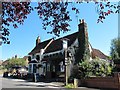
6
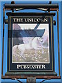
Sign for The Unicorn, Gallows Hill, WD4
See Image
Image: © Mike Quinn
Taken: 24 Jul 2012
0.13 miles
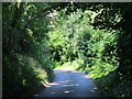
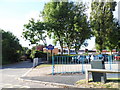
7
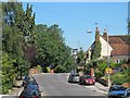
Gallows Hill, WD4 (2)
Shows the location of Image
Image: © Mike Quinn
Taken: 24 Jul 2012
0.14 miles
8
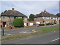
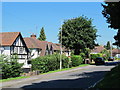
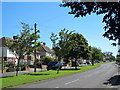
Gallows Hill Lane
1930s semis in Abbots Langley.
Image: © Burgess Von Thunen
Taken: 6 Sep 2012
0.14 miles