IMAGES TAKEN NEAR TO
Bridge Road, KINGS LANGLEY, WD4 8SZ
Introduction
This page details the photographs taken nearby to Bridge Road, WD4 8SZ by members of the Geograph project.
The Geograph project started in 2005 with the aim of publishing, organising and preserving representative images for every square kilometre of Great Britain, Ireland and the Isle of Man.

There are currently over 7.5m images from over14,400 individuals and you can help contribute to the project by visiting https://www.geograph.org.uk
Image Map
Images are licensed for reuse under creativecommons.org/licenses/by-sa/2.0
Notes
- Clicking on the map will re-center to the selected point.
- The higher the marker number, the further away the image location is from the centre of the postcode.
Image Listing (57 Images Found)
Images are licensed for reuse under creativecommons.org/licenses/by-sa/2.0
Image
Details
Distance
1
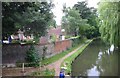
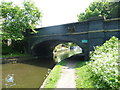
Canal at Hunton Bridge
This view is looking north. The building on the left used to be a school and is now office accommodation called "The Old Schoolhouse".
Image: © Jack Hill
Taken: 3 Jul 2005
0.01 miles
2
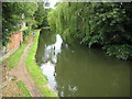
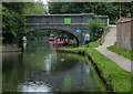
Grand Union Canal at Hunton Bridge
Originally opened here around 1798 as the Grand Junction Canal it was absorbed into the new Grand Union Canal in 1929. This is the view looking upstream from Bridge Road.
Image: © Nigel Cox
Taken: 19 Jul 2009
0.02 miles
4
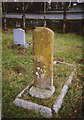
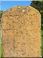
Old Milestone in St Paul's churchyard, Hunton Bridge, Abbots Langley
Carved stone post was on A281, in parish of Abbots Langley (Three Rivers District), was on Old Brighton Road, now used as a gravestone in St Paul's churchyard (2nd row fronting Watford Road), Langleybury, Herts. Cowfold stone erected by the Cowfold to Henfield (old) turnpike trust in the 19th century.
Inscription reads:-
BRIGHTON
1(9) MILES
HORSHAM
(??) MILES
Carved benchmark on base.
Milestone Society National ID: SX_LA31
Image: © C Woodward
Taken: 10 Jan 2012
0.02 miles
5
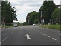
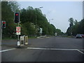
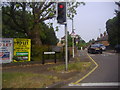
A41 - Hunton bridge crossroads & traffic lights
Image: © Peter Whatley
Taken: 19 Jun 2012
0.02 miles
6
Old Milestone by A41, in St Paul's churchyard
The Milestone, originally on the A281 at Bull's Head south of Cowfold (TQ 21233 22009), is now located in St Paul's churchyard on the West side of the road. Parish of Abbots Langley (Three Rivers District). Carved stone post, Cowfold stone design, originally erected by the Cowfold to Henfield (old) turnpike trust in the 19th Century. On the reverse is an inscription to a man who died in 1928. An earlier photograph appears here: https://www.geograph.org.uk/photo/6098429
Inscription reads:-
BRIGHTON / 15 MILES / HORSHAM / 7 MILES
Milestone Society National ID: SX_BRGF15
Image: © Andrew Knorpel
Taken: 7 Jun 2023
0.02 miles
7
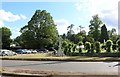
War memorial by St Paul's Church, Hunton Bridge
Image: © David Howard
Taken: 8 Jun 2019
0.03 miles
10
Hunton Bridge No 162
Bridge Road crossing the Grand Union Canal.
Image: © Mat Fascione
Taken: 18 Aug 2015
0.03 miles