IMAGES TAKEN NEAR TO
Primrose Hill, KINGS LANGLEY, WD4 8HX
Introduction
This page details the photographs taken nearby to Primrose Hill, WD4 8HX by members of the Geograph project.
The Geograph project started in 2005 with the aim of publishing, organising and preserving representative images for every square kilometre of Great Britain, Ireland and the Isle of Man.

There are currently over 7.5m images from over14,400 individuals and you can help contribute to the project by visiting https://www.geograph.org.uk
Image Map
Images are licensed for reuse under creativecommons.org/licenses/by-sa/2.0
Notes
- Clicking on the map will re-center to the selected point.
- The higher the marker number, the further away the image location is from the centre of the postcode.
Image Listing (63 Images Found)
Images are licensed for reuse under creativecommons.org/licenses/by-sa/2.0
Image
Details
Distance
1
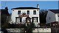
The Bell Inn, Primrose Hill
This pub is derelict.
Image: © Bryn Holmes
Taken: 11 Dec 2023
0.03 miles
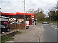
2
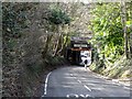
Road passes under west coast main line, Kings Langley
No room for a pavement
Image: © Bikeboy
Taken: 1 Feb 2014
0.09 miles

4
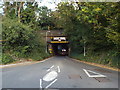
Railway bridge over Toms Lane, Kings Langley
This bridge carries the West Coast Main Line over Toms Lane.
Image: © Malc McDonald
Taken: 26 Sep 2015
0.10 miles
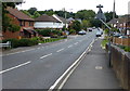
5
Water Lane at the junction of Primrose Hill
Image: © David Howard
Taken: 16 Apr 2015
0.10 miles
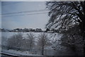
8
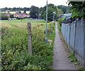
Footpath in Kings Langley
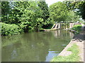
This path runs between the Grand Union Canal and Primrose Hill.
Image: © Mat Fascione
Taken: 18 Aug 2015
0.13 miles