IMAGES TAKEN NEAR TO
Wharf Way, KINGS LANGLEY, WD4 8FN
Introduction
This page details the photographs taken nearby to Wharf Way, WD4 8FN by members of the Geograph project.
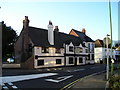
The Geograph project started in 2005 with the aim of publishing, organising and preserving representative images for every square kilometre of Great Britain, Ireland and the Isle of Man.

There are currently over 7.5m images from over14,400 individuals and you can help contribute to the project by visiting https://www.geograph.org.uk
Image Map
Images are licensed for reuse under creativecommons.org/licenses/by-sa/2.0
Notes
- Clicking on the map will re-center to the selected point.
- The higher the marker number, the further away the image location is from the centre of the postcode.
Image Listing (54 Images Found)
Images are licensed for reuse under creativecommons.org/licenses/by-sa/2.0
Image
Details
Distance
1
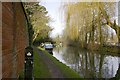
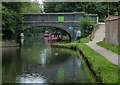
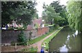
Grand Union Canal, Hunton Bridge
This is looking north from right beside bridge no. 162. In the days of commercial traffic the narrow boat pairs were often crewed by a husband and wife, with their children being conceived, born and brought up 'on the cut'. By the time the boats get here they have already worked 30 locks, with another 130 to go before Birmingham!
Image: © David Marsden
Taken: 22 Jan 2008
0.07 miles
2
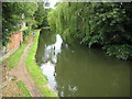
Grand Union Canal at Hunton Bridge
Originally opened here around 1798 as the Grand Junction Canal it was absorbed into the new Grand Union Canal in 1929. This is the view looking upstream from Bridge Road.
Image: © Nigel Cox
Taken: 19 Jul 2009
0.08 miles
3
The Waterside Tavern Pub, Hunton Bridge
Bridge Road, Hunton Bridge, Kings Langley WD4 8RF on the Grand Union Canal
Image: © canalandriversidepubs co uk
Taken: Unknown
0.08 miles
4
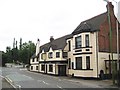
Hunton Bridge: The Waterside bar and pizzeria
Now an Italian restaurant http://www.watersidetavern.co.uk/home.htm this was formerly the Kings Head public house. It is over 300 years old and a Grade II listed building.
Image: © Nigel Cox
Taken: 19 Jul 2009
0.09 miles
5
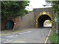
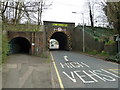
Hunton Bridge: Bridge Road bridge
Built as part of the original railway infrastructure and not for modern traffic this bridge still causes problems. The height restriction is 11' 6" and that is between the white vertical bars, so high vehicles have to pass in the centre of the bridge, as evidenced by the white arrow in the road. The road this side is Bridge Road, beyond the bridge it is Hunton Bridge Hill. On the left is a pedestrian tunnel.
Image: © Nigel Cox
Taken: 19 Jul 2009
0.09 miles
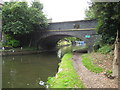
6
Hunton Bridge No 162
Bridge Road crossing the Grand Union Canal.
Image: © Mat Fascione
Taken: 18 Aug 2015
0.09 miles
7
Canal at Hunton Bridge
This view is looking north. The building on the left used to be a school and is now office accommodation called "The Old Schoolhouse".
Image: © Jack Hill
Taken: 3 Jul 2005
0.09 miles
8
Grand Union Canal: Bridge Road bridge at Hunton Bridge
The owners of Image seek the custom of the users of the canal by means of their black and gold sign on the bridge. The turquoise sign is one for a London Anglers' Association private fishery.
Image: © Nigel Cox
Taken: 19 Jul 2009
0.09 miles