IMAGES TAKEN NEAR TO
Grove Crescent, RICKMANSWORTH, WD3 3JP
Introduction
This page details the photographs taken nearby to Grove Crescent, WD3 3JP by members of the Geograph project.
The Geograph project started in 2005 with the aim of publishing, organising and preserving representative images for every square kilometre of Great Britain, Ireland and the Isle of Man.

There are currently over 7.5m images from over14,400 individuals and you can help contribute to the project by visiting https://www.geograph.org.uk
Image Map
Images are licensed for reuse under creativecommons.org/licenses/by-sa/2.0
Notes
- Clicking on the map will re-center to the selected point.
- The higher the marker number, the further away the image location is from the centre of the postcode.
Image Listing (24 Images Found)
Images are licensed for reuse under creativecommons.org/licenses/by-sa/2.0
Image
Details
Distance
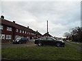
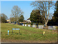
2
Former Durrants Secondary School, Croxley Green (1)
Situated at the end of Manor Way, this school opened in 1939 as a Senior Elementary School until 1945 when it became a County Secondary School. In 1968, it was redesignated as an all-ability school until its closure in July 1991. Housing now occupies the school site.
Image: © David Hillas
Taken: 5 Jan 1992
0.12 miles
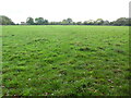
3
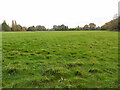
Field by Little Green Lane (3)
This field is between Little Green Lane and Manor Way. There is a proposal to build a school on this field, although it remains to be seen whether or not it will receive planning permission.
Image: © David Hillas
Taken: 28 Oct 2021
0.13 miles
5
Little Green Lane, Croxley Green
Showing part of the northern end of Croxley Green's extensive green. The exact purpose of the white barriers isn't clear.
Image: © Stephen McKay
Taken: 15 Feb 2023
0.16 miles
6
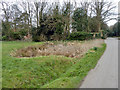
Small pond by Little Green Lane
At the northern extremity of Croxley Green's green.
Image: © Robin Webster
Taken: 27 Mar 2013
0.16 miles
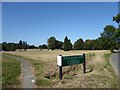
7
Field by Little Green Lane (1)
This photo shows the field from Little Green Lane towards houses in Manor Way. It used to belong to Durrants Secondary School nearby until it closed in July 1991.
Image: © David Hillas
Taken: 28 Oct 2021
0.17 miles
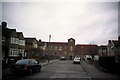
8
View from Little Green Lane across Croxley Green
This view looks across Croxley Green from the junction of Little Green Lane with The Green. Croxley House is hidden by the trees in the middle of the photograph. It is now a care home - see https://www.geograph.org.uk/photo/5919660
Image: © Marathon
Taken: 18 Sep 2019
0.17 miles
9
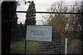
Durrants School notice, Croxley Green
This notice was taken in Rochester Way at the rear entrance to the school. As it indicates, the school was run by Hertfordshire County Council.
Image: © David Hillas
Taken: 5 Jan 1992
0.17 miles
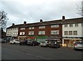
10
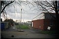
Former Durrants Secondary School, Croxley Green (2)
Taken in January 1992, this photo shows the rear view of the buildings that were erected in the mid-1960s for the school to become all-ability in 1968. Closure of the school took place in July 1991 and housing now occupies the site.
Image: © David Hillas
Taken: 5 Jan 1992
0.17 miles