IMAGES TAKEN NEAR TO
High Street, RICKMANSWORTH, WD3 1BQ
Introduction
This page details the photographs taken nearby to High Street, WD3 1BQ by members of the Geograph project.
The Geograph project started in 2005 with the aim of publishing, organising and preserving representative images for every square kilometre of Great Britain, Ireland and the Isle of Man.

There are currently over 7.5m images from over14,400 individuals and you can help contribute to the project by visiting https://www.geograph.org.uk
Image Map
Images are licensed for reuse under creativecommons.org/licenses/by-sa/2.0
Notes
- Clicking on the map will re-center to the selected point.
- The higher the marker number, the further away the image location is from the centre of the postcode.
Image Listing (141 Images Found)
Images are licensed for reuse under creativecommons.org/licenses/by-sa/2.0
Image
Details
Distance
1
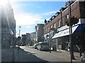
Street Scene in Rickmansworth
The lack of shoppers surprised me but it does have a pedestrian precinct atmosphere
Image: © Jack Hill
Taken: 12 Jul 2005
0.06 miles
2
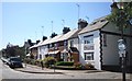
High Street Houses, Rickmansworth
Residential part of the High Street to the West of the shopping area. The height of the TV aerials suggests that the signal is not too good here.
Image: © Des Blenkinsopp
Taken: 23 Jul 2012
0.07 miles
3
Rickmansworth Telephone Exchange (2)
Rear view taken from Parsonage Road near Rectory Road.
Image: © David Hillas
Taken: 1 Oct 2008
0.08 miles
4
Rickmansworth Telephone Exchange (1)
Situated in Rectory Lane, it is behind the Royal Mail Rickmansworth Delivery Office. It has the code LWRIC and serves 10,884 residential and 600 non-residential premises in Rickmansworth plus Croxley Green (part), Loudwater, Maple Cross and Mill End nearby. Its postcode is WD3 1FB.
Image: © David Hillas
Taken: 1 Oct 2008
0.08 miles
5
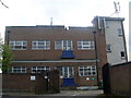
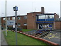
Rickmansworth Police Station (closed)
This photo shows the police station in Rectory Road shortly after closure in early February,2011. The banner above the entrance says the following: "Rickmansworth Police Station has moved to Three Rivers House, Northway, Rickmansworth, WD3 1RL. If you need urgent police assistance please call 999, otherwise contact Hertfordshire Constabulary on 0845 33 00 222".
Image: © David Hillas
Taken: 22 Feb 2011
0.09 miles
6
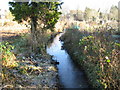
Rickmansworth: Town Ditch (6)
Town Ditch is the main watercourse of the old field drain system built to improve and manage drainage in the town many years ago. It starts as an outfall from the River Chess to the east of the town before flowing into the River Colne to the west. Here it is looking upstream from the footbridge at the entrance to the Ebury Road allotment gardens.
Image: © Nigel Cox
Taken: 21 Jan 2009
0.09 miles
7
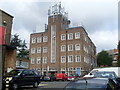
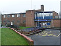
Rickmansworth Police Station
Situated in Rectory Road, this police station, belonging to Hertfordshire Constabulary, dates from the 1950s. Shortly after this photo was taken, it was closed and services transferred to Three Rivers House, TQ0694 refers http://www.geograph.org.uk/photo/2285172. Its postcode is WD3 1FJ.
Image: © David Hillas
Taken: 1 Feb 2011
0.09 miles
8
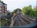
Rickmansworth Station
A view taken from the footbridge east of the station showing a northbound Metropolitan Line train about to depart for Amersham (and for those who collect such things, no, I did not get its number!). (The blurred grey line at the bottom of the image is part of the dense mesh security screen on the footbridge - apologies for this!) These tracks are shared between London Underground and Chiltern Railways. The London Underground trains go to and from Amersham and Baker Street and Aldgate, and the Chiltern Line trains run from London Marylebone to and from Aylesbury.
Image: © Nigel Cox
Taken: 23 Oct 2005
0.09 miles
10
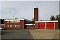
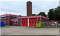
Rickmansworth fire station
Rickmansworth fire station, Rectory Road, Rickmansworth, Hertfordshire
Image: © Kevin Hale
Taken: 12 Nov 2006
0.09 miles