IMAGES TAKEN NEAR TO
Ebury Road, RICKMANSWORTH, WD3 1BH
Introduction
This page details the photographs taken nearby to Ebury Road, WD3 1BH by members of the Geograph project.
The Geograph project started in 2005 with the aim of publishing, organising and preserving representative images for every square kilometre of Great Britain, Ireland and the Isle of Man.

There are currently over 7.5m images from over14,400 individuals and you can help contribute to the project by visiting https://www.geograph.org.uk
Image Map
Images are licensed for reuse under creativecommons.org/licenses/by-sa/2.0
Notes
- Clicking on the map will re-center to the selected point.
- The higher the marker number, the further away the image location is from the centre of the postcode.
Image Listing (201 Images Found)
Images are licensed for reuse under creativecommons.org/licenses/by-sa/2.0
Image
Details
Distance
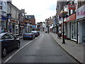
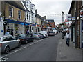
1
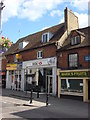
Bury Lane, Rickmansworth
Looking towards the High Street.
Image: © Stephen McKay
Taken: 11 Jan 2017
0.01 miles
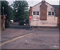
2

Ebury Hall, Rickmansworth (1)
Taken in December 1972, this photo shows Ebury Hall at the corner of Bury Lane and Ebury Road. It was donated by Lord Ebury in 1901 to the Parish of Rickmansworth and had been used as a meeting place by local organisations since then.However, it closed during the late 1970s and was then partly demolished although the front of it remains to this day. Offices now occupy this building and its postcode is WD3 1BH. The bridge and road in the foreground used to be known as the Water Splash with a stream crossing over it. However, it was built over in late 1963 after the ford froze in the Winter of 1962/3.
Image: © David Hillas
Taken: 9 Dec 1972
0.01 miles
3
Ebury Hall, Rickmansworth (2)
Taken in May 1982, this photo shows Ebury Hall at the corner of Ebury Road and Bury Lane. It dates from 1901 and was named after Lord Ebury. However, it closed as a public meeting place in the late 1970s and is now used as offices. The road to the left of Ebury Hall is Bury Lane which led to The Bury in the distance. There used to be a stream, known as the watersplash, which crossed Bury Lane just beyond Ebury Hall, but it froze during the severe Winter of 1962/3 and was subsequently culverted in the Autumn of 1963.
Image: © David Hillas
Taken: 17 May 1982
0.01 miles
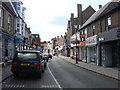
4
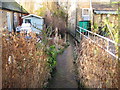
Rickmansworth: Town Ditch (4)
Town Ditch is the main watercourse of the old field drain system built to improve and manage drainage in the town many years ago. It starts as an outfall from the River Chess to the east of the town before flowing into the River Colne to the west. Here it is, tucked away between buildings, viewed looking downstream from the Bury Lane bridge. Please see Image in the grid square to the east for the preceding image in the sequence.
Image: © Nigel Cox
Taken: 21 Jan 2009
0.02 miles
5
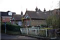
Beresford Almshouses, Rickmansworth
Built in 1894.
Image: © Jim Osley
Taken: 20 Nov 2014
0.02 miles
7
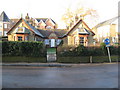
Rickmansworth: Beresford Almshouses
The Almshouses were bequeathed by John Beresford who made his fortune from dealing in gunpowder during the English Civil War between 1642 and 1651. This is not the original location of the almshouses, these replacement dwellings having been built here in Bury Lane in 1894. Chesswood Court is the modern residential building behind.
Image: © Nigel Cox
Taken: 21 Jan 2009
0.03 miles