IMAGES TAKEN NEAR TO
Lemonfield Drive, WATFORD, WD25 9TU
Introduction
This page details the photographs taken nearby to Lemonfield Drive, WD25 9TU by members of the Geograph project.
The Geograph project started in 2005 with the aim of publishing, organising and preserving representative images for every square kilometre of Great Britain, Ireland and the Isle of Man.

There are currently over 7.5m images from over14,400 individuals and you can help contribute to the project by visiting https://www.geograph.org.uk
Image Map
Images are licensed for reuse under creativecommons.org/licenses/by-sa/2.0
Notes
- Clicking on the map will re-center to the selected point.
- The higher the marker number, the further away the image location is from the centre of the postcode.
Image Listing (8 Images Found)
Images are licensed for reuse under creativecommons.org/licenses/by-sa/2.0
Image
Details
Distance
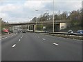
1
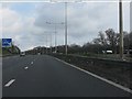
St Albans City and District : M1 Motorway
The M1 Motorway between Junction 6 (Waterdale) and Junction 5 (Berrygrove).
Image: © Lewis Clarke
Taken: 3 Oct 2018
0.09 miles
2
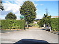
The entrance to Coates Way JMI school, Garston
Image: © David Howard
Taken: 19 Sep 2012
0.11 miles
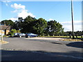
3
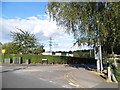
Coates Dell at the junction of Coates Way, Garston
Overlooking Coates Way School
Image: © David Howard
Taken: 19 Sep 2012
0.14 miles
4
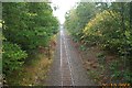
Railway through Bricket Wood Common
A view looking northwards through the wooded setting of Bricket Wood Common, towards the Bucknalls Lane overbridge, with Bricket Wood station beyond, on the Abbey Flyer railway line between Watford Junction and St. Albans Abbey stations.
Image: © Nigel Cox
Taken: 29 Oct 2005
0.17 miles
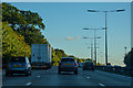
7
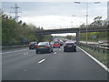
M1 northbound passes under Bucknalls Lane
Image: © Colin Pyle
Taken: 19 Apr 2015
0.23 miles