IMAGES TAKEN NEAR TO
Anvil Mews, WATFORD, WD25 8EY
Introduction
This page details the photographs taken nearby to Anvil Mews, WD25 8EY by members of the Geograph project.
The Geograph project started in 2005 with the aim of publishing, organising and preserving representative images for every square kilometre of Great Britain, Ireland and the Isle of Man.

There are currently over 7.5m images from over14,400 individuals and you can help contribute to the project by visiting https://www.geograph.org.uk
Image Map
Images are licensed for reuse under creativecommons.org/licenses/by-sa/2.0
Notes
- Clicking on the map will re-center to the selected point.
- The higher the marker number, the further away the image location is from the centre of the postcode.
Image Listing (17 Images Found)
Images are licensed for reuse under creativecommons.org/licenses/by-sa/2.0
Image
Details
Distance
1
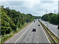
M1 looking southbound
Between junctions 5 and 4.
Image: © Robin Webster
Taken: 10 Jun 2015
0.04 miles
2
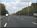
M1 motorway north of Sandy Lane
Traces of the second of two power lines crossing the M1 can be seen top left of the photo.
Image: © Peter Whatley
Taken: 3 Apr 2012
0.07 miles
3
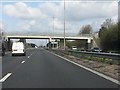
M1 motorway - Patchetts accommodation bridge
Image: © Peter Whatley
Taken: 3 Apr 2012
0.09 miles
4
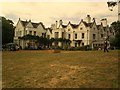
Delrow House
Delrow House is a Grade 2 listed building. There has been a house here since 1666 but most of the present form dates to the nineteenth century. It is now the centre of a Camphill Community for adults suffering from mental health problems and learning disabilities.
Image: © Graham Hale
Taken: 5 Jul 2010
0.09 miles
5
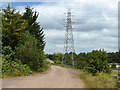
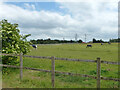
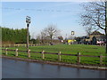
Track and pylon
The track is used by a public footpath from the A41 to Patchetts Green. A bridge over the M1 can just be glimpsed round the corner.
Image: © Robin Webster
Taken: 10 Jun 2015
0.10 miles
9
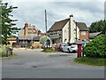
Patchetts Green
The village sign is the nearer of the two, the far one being for The Three Compasses Public House. View taken looking eastwards from Hilfield Lane towards Pegmire Lane.
Image: © Nigel Cox
Taken: 10 Dec 2005
0.15 miles