IMAGES TAKEN NEAR TO
Robin Place, Boundary Way, WATFORD, WD25 7SN
Introduction
This page details the photographs taken nearby to Robin Place, Boundary Way, WD25 7SN by members of the Geograph project.
The Geograph project started in 2005 with the aim of publishing, organising and preserving representative images for every square kilometre of Great Britain, Ireland and the Isle of Man.

There are currently over 7.5m images from over14,400 individuals and you can help contribute to the project by visiting https://www.geograph.org.uk
Image Map
Images are licensed for reuse under creativecommons.org/licenses/by-sa/2.0
Notes
- Clicking on the map will re-center to the selected point.
- The higher the marker number, the further away the image location is from the centre of the postcode.
Image Listing (2 Images Found)
Images are licensed for reuse under creativecommons.org/licenses/by-sa/2.0
Image
Details
Distance
1
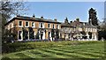
High Elms Manor, near Garston, Hertfordshire
High Elms Manor is a grade II listed Georgian country house located near Garston in Hertfordshire, England. It was built in around 1812, and was originally known as "High Elms", but from the 1890's to 2010 it was called Garston Manor.
In the post World War II years the house was a rehabilitation centre, but it later fell derelict. In the 1990's an American named Sheila O'Neill bought and restored it and used it as a Montessori School.
https://en.wikipedia.org/wiki/High_Elms_Manor#cite_note-2
High Elms Manor
Image: © Raibeart MacAoidh
Taken: 21 Apr 2018
0.13 miles
2
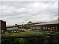
Parmiters School Waterdale
This area is well endowed with schools. This one has many computers displayed for all to see.
Image: © Jack Hill
Taken: 12 Aug 2005
0.25 miles