IMAGES TAKEN NEAR TO
Poundfield, WATFORD, WD25 7AB
Introduction
This page details the photographs taken nearby to Poundfield, WD25 7AB by members of the Geograph project.
The Geograph project started in 2005 with the aim of publishing, organising and preserving representative images for every square kilometre of Great Britain, Ireland and the Isle of Man.

There are currently over 7.5m images from over14,400 individuals and you can help contribute to the project by visiting https://www.geograph.org.uk
Image Map
Images are licensed for reuse under creativecommons.org/licenses/by-sa/2.0
Notes
- Clicking on the map will re-center to the selected point.
- The higher the marker number, the further away the image location is from the centre of the postcode.
Image Listing (12 Images Found)
Images are licensed for reuse under creativecommons.org/licenses/by-sa/2.0
Image
Details
Distance
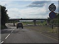
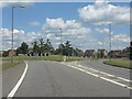
1

Ashfields towards junction with Aerodrome Way
The road layout in this area is remarkably complicated, revision upon revision upon revision.
Image: © Robin Webster
Taken: 2 May 2021
0.06 miles
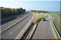
3
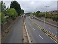
Watford: A41 North Western Avenue
This is the view looking west from the footbridge that connects Leggatts Way and the present-day Leggatts Rise. When it was first built this section of the current A41 was the A500, and was also known then as Leggatts Rise.
The slip road on the left leads up to the elevated roundabout junction with the A405 North Orbital Road. The 1939 large scale OS map shows that when these two roads were first built, the A405 Kingsway North Orbital Road, as it then was, formed a T-junction with the A500.
Image: © Nigel Cox
Taken: 3 Sep 2020
0.10 miles
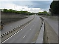
4
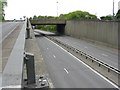
North Western Avenue
The A41, looking west at its junction with Kingsway North Orbital Road [A405].
Image: © M J Richardson
Taken: 26 Apr 2010
0.12 miles
5
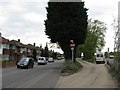
Bus-only access to North Western Avenue
From Leggats Way to the A41.
Image: © M J Richardson
Taken: 26 Apr 2010
0.14 miles
6
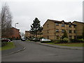
Courtlands Close
An estate of 3-storey blocks containing six or twelve flats. Built about 1990.
Image: © Keith Edkins
Taken: 2 Mar 2013
0.16 miles
7
North Western Avenue, looking east
The A41 near North Watford, looking towards London.
Image: © M J Richardson
Taken: 26 Apr 2010
0.20 miles
8
Leavesden Green: A41 North Western Avenue
Viewed looking westwards towards the Hunton Bridge roundabout from the Ashfields overbridge. The disused Leavesden Aerodrome, which is to the right, has been partially redeveloped for housing, and the rest is now Leavesden Film Studios. One of the ventilation shafts for the Watford main line railway tunnels is just (!) visible between the lamp posts on the central reservation.
Image: © Nigel Cox
Taken: 16 Oct 2005
0.20 miles
9
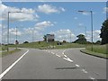
New triangular road junction, Leavesden Green
Image: © Peter Whatley
Taken: 19 Jun 2012
0.20 miles
10
Aerodrome Way roundabout, Leavesden Green
Image: © Peter Whatley
Taken: 19 Jun 2012
0.22 miles