IMAGES TAKEN NEAR TO
Sheepcot Lane, WATFORD, WD25 0EB
Introduction
This page details the photographs taken nearby to Sheepcot Lane, WD25 0EB by members of the Geograph project.
The Geograph project started in 2005 with the aim of publishing, organising and preserving representative images for every square kilometre of Great Britain, Ireland and the Isle of Man.

There are currently over 7.5m images from over14,400 individuals and you can help contribute to the project by visiting https://www.geograph.org.uk
Image Map
Images are licensed for reuse under creativecommons.org/licenses/by-sa/2.0
Notes
- Clicking on the map will re-center to the selected point.
- The higher the marker number, the further away the image location is from the centre of the postcode.
Image Listing (4 Images Found)
Images are licensed for reuse under creativecommons.org/licenses/by-sa/2.0
Image
Details
Distance

3
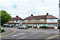
Watford: Kingswood Estate
A view looking westwards down Kingswood Road from its junction with Moss Road, this estate of 1920s - 1940s housing covers the southern third of this grid square.
Image: © Nigel Cox
Taken: 30 Oct 2005
0.23 miles