IMAGES TAKEN NEAR TO
Gammons Lane, WATFORD, WD24 5JN
Introduction
This page details the photographs taken nearby to Gammons Lane, WD24 5JN by members of the Geograph project.
The Geograph project started in 2005 with the aim of publishing, organising and preserving representative images for every square kilometre of Great Britain, Ireland and the Isle of Man.

There are currently over 7.5m images from over14,400 individuals and you can help contribute to the project by visiting https://www.geograph.org.uk
Image Map
Images are licensed for reuse under creativecommons.org/licenses/by-sa/2.0
Notes
- Clicking on the map will re-center to the selected point.
- The higher the marker number, the further away the image location is from the centre of the postcode.
Image Listing (15 Images Found)
Images are licensed for reuse under creativecommons.org/licenses/by-sa/2.0
Image
Details
Distance

2
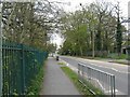
Leggats Way, North Watford
By the entrance to the Harebreaks Local Nature Reserve.
Image: © M J Richardson
Taken: 26 Apr 2010
0.11 miles
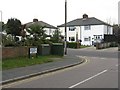
3
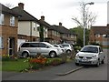
Leaford Crescent, North Watford
Original 1960s houses on the left, with an addition to the right of newer houses.
Image: © M J Richardson
Taken: 26 Apr 2010
0.11 miles
4
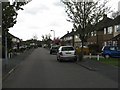
Leaford Crescent
Off Gammons Lane, a crescent of 1960s houses.
Image: © M J Richardson
Taken: 26 Apr 2010
0.13 miles

6
Harebreaks Wood Local Nature Reserve
Image: © M J Richardson
Taken: 26 Apr 2010
0.14 miles
7
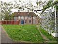
Hertfordshire County Council buildings
A sign indicates the ownership, and 'keep out'. The map indicates that it is a college - not clear whether the buildings are still in use.
Image: © M J Richardson
Taken: 26 Apr 2010
0.15 miles
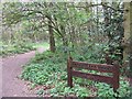
8
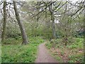
Harebreaks Wood
A local nature reserve in North Watford.
Image: © M J Richardson
Taken: 26 Apr 2010
0.15 miles
9
Leaford Crescent, junction with Gammons Lane
Image: © M J Richardson
Taken: 26 Apr 2010
0.15 miles
10
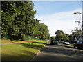
The Harebreaks, North Watford
Harebreaks Recreation Ground is on the left.
Image: © David Howard
Taken: 6 Sep 2012
0.16 miles