IMAGES TAKEN NEAR TO
Parker Street, WATFORD, WD24 5EY
Introduction
This page details the photographs taken nearby to Parker Street, WD24 5EY by members of the Geograph project.
The Geograph project started in 2005 with the aim of publishing, organising and preserving representative images for every square kilometre of Great Britain, Ireland and the Isle of Man.

There are currently over 7.5m images from over14,400 individuals and you can help contribute to the project by visiting https://www.geograph.org.uk
Image Map
Images are licensed for reuse under creativecommons.org/licenses/by-sa/2.0
Notes
- Clicking on the map will re-center to the selected point.
- The higher the marker number, the further away the image location is from the centre of the postcode.
Image Listing (37 Images Found)
Images are licensed for reuse under creativecommons.org/licenses/by-sa/2.0
Image
Details
Distance
1
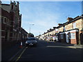
Leavesden Road, Watford
Leavesden Road Baptist Church is on the left.
Image: © David Howard
Taken: 6 Sep 2012
0.07 miles
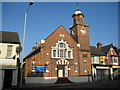
2
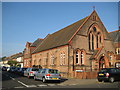
Watford: Leavesden Road Baptist Church (1)
Leavesden Road Baptist Church is at the junction of that road and Garfield Street. It is formed of this single Victorian building of 1895 surrounded by a later Edwardian extension in darker brickwork Image, with frontages onto both roads.
Image: © Nigel Cox
Taken: 21 Sep 2008
0.08 miles
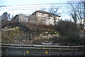
3
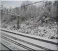
West Coast Main Line north of Watford Junction
Image: © N Chadwick
Taken: 19 Dec 2010
0.08 miles
4
Watford: Leavesden Road Baptist Church (2)
This is the Leavesden Road frontage of the Edwardian extension to the original Victorian church Image The foundation stone of this extension was laid in 1909. The church was the subject of major refurbishment works between 1993 and 1996.
Image: © Nigel Cox
Taken: 21 Sep 2008
0.09 miles
5
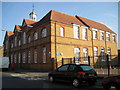
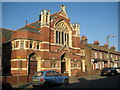
Watford: Former Callowland Infants School
Built in Leavesden Road, probably around 1890, to serve the rapidly expanding community in Victorian North Watford, the school has now closed and been converted into apartments.
Image: © Nigel Cox
Taken: 21 Sep 2008
0.09 miles
7
Watford: Christ Church
Christ Church in St Albans Road was built to the serve the growing community in North Watford that lived in the rapidly expanding area of late Victorian residential housing north of the railway line. This church was built by the local firm of Darvills and consecrated in 1905. It replaced a short lived iron church of 1896. Christ Church was originally a chapel of ease to Image, but became a parish in its own right in 1909.
Image: © Nigel Cox
Taken: 21 Sep 2008
0.12 miles
8
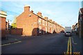
Watford: Leavesden Road
Neat Victorian terraced housing, although not entirely typical of most of the housing in this grid square - most houses have small front yards. Leavesden Road viewed looking northwards at the junction with Copsewood Road.
Image: © Nigel Cox
Taken: 5 Nov 2005
0.12 miles
10
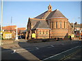
Watford Elim Church
Watford's Elim Church is here in St Albans Road and was formerly a Primitive Methodist Church, with quite elaborate architecture for a building of that ilk. The curtilage of the site stretches back from St Albans Road to Leavesden Road and looking at old Ordnance Survey maps it is evident that the first development on the site was a small chapel on the Leavesden Road frontage, shown on the map of 1899.
Image: © Nigel Cox
Taken: 21 Sep 2008
0.13 miles