IMAGES TAKEN NEAR TO
Lincoln Drive, WATFORD, WD19 7GE
Introduction
This page details the photographs taken nearby to Lincoln Drive, WD19 7GE by members of the Geograph project.
The Geograph project started in 2005 with the aim of publishing, organising and preserving representative images for every square kilometre of Great Britain, Ireland and the Isle of Man.

There are currently over 7.5m images from over14,400 individuals and you can help contribute to the project by visiting https://www.geograph.org.uk
Image Map
Images are licensed for reuse under creativecommons.org/licenses/by-sa/2.0
Notes
- Clicking on the map will re-center to the selected point.
- The higher the marker number, the further away the image location is from the centre of the postcode.
Image Listing (24 Images Found)
Images are licensed for reuse under creativecommons.org/licenses/by-sa/2.0
Image
Details
Distance
6
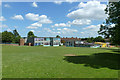
St. Joseph's Catholic Primary School
The entrance is on Ainsdale Road.
Image: © Robin Webster
Taken: 7 Jun 2015
0.14 miles
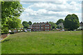
7
Oxhey Drive, South Oxhey
The large London County Council development at South Oxhey was built in the early 1950s to relieve overcrowding in the inner city, where much of the housing stock had been lost due to wartime bombing. The houses here are typical of local authority estates of the era including this terrace on Oxhey Drive. The houses were generally well-built and relatively sizeable with decent gardens - in some ways better than their equivalents built for the private market. They must have seemed like paradise for many of their first residents. Today a majority of the houses at South Oxhey are privately owned.
Image: © Stephen McKay
Taken: 5 Apr 2022
0.16 miles
8
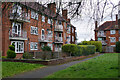
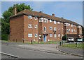
Forfar House, South Oxhey
Forfar House is an apartment block which, together with two similar blocks, overlooks a green off Oxhey Drive. Part of Filton House can be seen in this picture. The estate at South Oxhey was developed by the then London County Council (LCC) in the early 1950s, one of a number built on the fringes of London to help relieve overcrowding in the inner city area. It was not actually within the LCC's area and is still within the modern boundaries of Hertfordshire today. In 1980 the Greater London Council (which had absorbed the LCC) passed the ownership and management of the estate to Three Rivers District Council. Today, a large proportion of the housing stock is privately owned and the remaining social housing has been transferred to a housing association.
Image: © Stephen McKay
Taken: 5 Apr 2022
0.18 miles
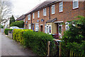
9
South Oxhey: Offerton House
The South Oxhey housing estate was originally one of several built by the London County Council outside London in the immediate post-war years of the late 1940s and early 1950s to provide residences for Londoners whose homes had been damaged in the war or were otherwise of poor quality. Management of the estate passed to the Greater London Council in 1965, and eventually, in 1980, to Three Rivers District Council, although it is estimated that at least 70% of the property is now privately owned.
Offerton House is one of several original blocks of flats of very similar design on the estate and is on the north side of Oxhey Drive.
Image: © Nigel Cox
Taken: 28 Jun 2009
0.19 miles
10
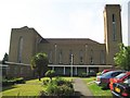
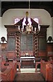
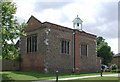
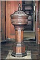
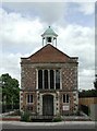
South Oxhey: St Joseph's Catholic Church
The church was founded in 1952 to serve the London County Council built South Oxhey housing estate. The church was built here, on the south side of Oxhey Drive, in 1960 and consecrated in 1981. Its website is here http://www.rcdow.org.uk/CarpendersPark/ The Church belongs to the Roman Catholic Diocese of Westminster.
Despite being such a large building with a prominent tower overlooking South Oxhey it is difficult to photograph being surrounded by houses on its eastern, southern and western sides. As can be seen this tower has been an obvious target for mobile telephone companies wishing to use it for mounting their masts.
From a Geograph point of view the Ordnance Survey's 193000 metre gridline runs through the church, from right to left in this photograph, so the opposite and southern side of the structure is in Image
Image: © Nigel Cox
Taken: 28 Jun 2009
0.20 miles