IMAGES TAKEN NEAR TO
Hayling Road, WATFORD, WD19 7DP
Introduction
This page details the photographs taken nearby to Hayling Road, WD19 7DP by members of the Geograph project.
The Geograph project started in 2005 with the aim of publishing, organising and preserving representative images for every square kilometre of Great Britain, Ireland and the Isle of Man.

There are currently over 7.5m images from over14,400 individuals and you can help contribute to the project by visiting https://www.geograph.org.uk
Image Map
Images are licensed for reuse under creativecommons.org/licenses/by-sa/2.0
Notes
- Clicking on the map will re-center to the selected point.
- The higher the marker number, the further away the image location is from the centre of the postcode.
Image Listing (14 Images Found)
Images are licensed for reuse under creativecommons.org/licenses/by-sa/2.0
Image
Details
Distance

5
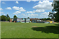
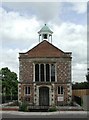
St. Joseph's Catholic Primary School
The entrance is on Ainsdale Road.
Image: © Robin Webster
Taken: 7 Jun 2015
0.16 miles
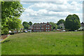
7
Catharine House, Gosforth Lane, South Oxhey
The end of quite a long building, retirement housing. The bus stop is Harewood Road.
Image: © Robin Webster
Taken: 7 Jun 2015
0.19 miles
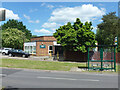
8

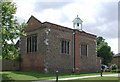
South Oxhey Baptist Church
On Gosforth Lane.
Image: © Robin Webster
Taken: 7 Jun 2015
0.21 miles
9
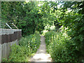
Footpath Watford Rural 11 to Oxhey Drive
Through part of Oxhey Woods.
Image: © Robin Webster
Taken: 7 Jun 2015
0.21 miles