IMAGES TAKEN NEAR TO
Bowring Green, WATFORD, WD19 6UP
Introduction
This page details the photographs taken nearby to Bowring Green, WD19 6UP by members of the Geograph project.
The Geograph project started in 2005 with the aim of publishing, organising and preserving representative images for every square kilometre of Great Britain, Ireland and the Isle of Man.

There are currently over 7.5m images from over14,400 individuals and you can help contribute to the project by visiting https://www.geograph.org.uk
Image Map
Images are licensed for reuse under creativecommons.org/licenses/by-sa/2.0
Notes
- Clicking on the map will re-center to the selected point.
- The higher the marker number, the further away the image location is from the centre of the postcode.
Image Listing (40 Images Found)
Images are licensed for reuse under creativecommons.org/licenses/by-sa/2.0
Image
Details
Distance
5
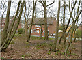
Houses on Bowring Green
Looking out of Nanscot Wood.
Image: © Robin Webster
Taken: 23 Feb 2013
0.06 miles
8
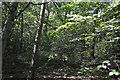
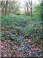
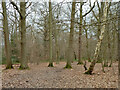
Path in Nanscot Wood
The path is part of the London LOOP https://tfl.gov.uk/modes/walking/loop-walk .
Image: © Mike Quinn
Taken: 9 Oct 2019
0.06 miles
10
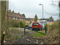
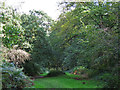
A way out of Nanscot Wood
To the residential Bowring Green.
Image: © Robin Webster
Taken: 23 Feb 2013
0.07 miles