IMAGES TAKEN NEAR TO
Prestwick Road, WATFORD, WD19 6EJ
Introduction
This page details the photographs taken nearby to Prestwick Road, WD19 6EJ by members of the Geograph project.
The Geograph project started in 2005 with the aim of publishing, organising and preserving representative images for every square kilometre of Great Britain, Ireland and the Isle of Man.

There are currently over 7.5m images from over14,400 individuals and you can help contribute to the project by visiting https://www.geograph.org.uk
Image Map
Images are licensed for reuse under creativecommons.org/licenses/by-sa/2.0
Notes
- Clicking on the map will re-center to the selected point.
- The higher the marker number, the further away the image location is from the centre of the postcode.
Image Listing (25 Images Found)
Images are licensed for reuse under creativecommons.org/licenses/by-sa/2.0
Image
Details
Distance
1
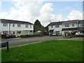
Glencorse Green
Prefabricated 1950s council houses in South Oxhey.
Image: © Burgess Von Thunen
Taken: 20 Jun 2012
0.03 miles
2
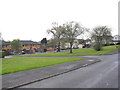
Caldwell Road
Open space in South Oxhey.
Image: © Burgess Von Thunen
Taken: 24 Apr 2012
0.04 miles
3
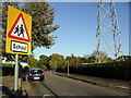
Woodhall Lane
School sign and electricity pylon in South Oxhey.
Image: © Burgess Von Thunen
Taken: 26 Oct 2011
0.08 miles
4
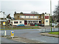
The Dick Whittington, South Oxhey
On Prestwick Road.
Image: © Robin Webster
Taken: 23 Feb 2013
0.13 miles
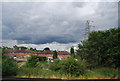
5
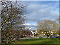
Little Oxhey Lane
Overlooking Prestwick Road
Image: © David Howard
Taken: 16 Feb 2011
0.15 miles
6
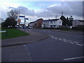
Junction of Woodhall Lane and Little Oxhey Lane, South Oxhey
Image: © David Howard
Taken: 16 Feb 2011
0.15 miles
8
West Coast Main Line
From the footpath by Little Oxhey Lane looking along the West Coast Main Line to Carpenders Park
Image: © Shaun Ferguson
Taken: 15 May 2019
0.16 miles
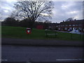
9
Green on the South Oxhey Estate
This small green is in the angle of Prestwick Road and Little Oxhey Lane. The cars directly ahead are on the mini roundabout where Little Oxhey Lane on the right meets Prestwick Road straight ahead. Another view of it can be seen at https://www.geograph.org.uk/photo/6039637
Image: © Marathon
Taken: 30 Jan 2019
0.16 miles
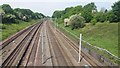
10
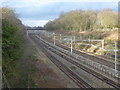
The West Coast Main line seen from Little Oxhey Lane
The London & Birmingham Railway opened from Euston to Boxmoor in 1837 and on to Birmingham in 1838. In 1846 it became part of the London & North Western Railway. Suburban trains were diverted from 15th June 1912 to run over the "New Lines", which had just been built between Euston and Watford Junction.
The nearest two lines are served by London Overground, the middle two lines are for fast trains and the furthest two lines are for semi-fast and freight trains. The next station in this direction is Carpenders Park. The view is from Little Oxhey Lane which is also followed by the London LOOP here.
Image: © Marathon
Taken: 30 Jan 2019
0.17 miles