IMAGES TAKEN NEAR TO
Oxhey Lane, WATFORD, WD19 5RE
Introduction
This page details the photographs taken nearby to Oxhey Lane, WD19 5RE by members of the Geograph project.
The Geograph project started in 2005 with the aim of publishing, organising and preserving representative images for every square kilometre of Great Britain, Ireland and the Isle of Man.

There are currently over 7.5m images from over14,400 individuals and you can help contribute to the project by visiting https://www.geograph.org.uk
Image Map
Images are licensed for reuse under creativecommons.org/licenses/by-sa/2.0
Notes
- Clicking on the map will re-center to the selected point.
- The higher the marker number, the further away the image location is from the centre of the postcode.
Image Listing (3 Images Found)
Images are licensed for reuse under creativecommons.org/licenses/by-sa/2.0
Image
Details
Distance
1
Pinner Road at the junction of Sherwoods Road
Image: © David Howard
Taken: 30 May 2021
0.19 miles
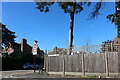
2

Pinner Road, corner of Watford Heath, Oxhey
Image: © David Howard
Taken: 16 Feb 2011
0.22 miles
3
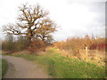
Bushey: Merry Hill
In 1996 the Woodland Trust and local communities purchased about 73 hectares or about 180 acres of the farmland of Merry Hill Farm in Bushey and set about converting the mainly arable farmland back to meadows and woodland for the public to access. About 60,000 new trees were planted.
In this view old mature oaks that formed the original field boundaries are on the left while one of the areas of new planting is on the right.
Image: © Nigel Cox
Taken: 22 Jan 2012
0.24 miles