IMAGES TAKEN NEAR TO
The Courtway, WATFORD, WD19 5DP
Introduction
This page details the photographs taken nearby to The Courtway, WD19 5DP by members of the Geograph project.
The Geograph project started in 2005 with the aim of publishing, organising and preserving representative images for every square kilometre of Great Britain, Ireland and the Isle of Man.

There are currently over 7.5m images from over14,400 individuals and you can help contribute to the project by visiting https://www.geograph.org.uk
Image Map
Images are licensed for reuse under creativecommons.org/licenses/by-sa/2.0
Notes
- Clicking on the map will re-center to the selected point.
- The higher the marker number, the further away the image location is from the centre of the postcode.
Image Listing (2 Images Found)
Images are licensed for reuse under creativecommons.org/licenses/by-sa/2.0
Image
Details
Distance
1
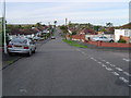
Carpenders Park: Greenfield Avenue
Viewed looking westwards in the housing estate where the properties are predominantly bungalows.
Image: © Nigel Cox
Taken: 12 Nov 2005
0.12 miles
2
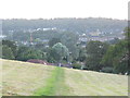
View across Carpenders Park from Merry Hill
Image: © David Howard
Taken: 13 Sep 2012
0.21 miles