IMAGES TAKEN NEAR TO
Dunsmore, The Hoe, WATFORD, WD19 5AU
Introduction
This page details the photographs taken nearby to Dunsmore, The Hoe, WD19 5AU by members of the Geograph project.
The Geograph project started in 2005 with the aim of publishing, organising and preserving representative images for every square kilometre of Great Britain, Ireland and the Isle of Man.

There are currently over 7.5m images from over14,400 individuals and you can help contribute to the project by visiting https://www.geograph.org.uk
Image Map
Images are licensed for reuse under creativecommons.org/licenses/by-sa/2.0
Notes
- Clicking on the map will re-center to the selected point.
- The higher the marker number, the further away the image location is from the centre of the postcode.
Image Listing (5 Images Found)
Images are licensed for reuse under creativecommons.org/licenses/by-sa/2.0
Image
Details
Distance
1
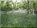
Carpenders Park: Sherwoods Wood
A fine display of bluebells is on show in this woodland glade.
Image: © Nigel Cox
Taken: 21 Apr 2009
0.11 miles
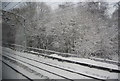
2
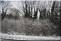
Trees by the West Coast Main Line north of Carpender's Park Station
Image: © N Chadwick
Taken: 19 Dec 2010
0.12 miles
3
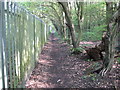
Carpenders Park: Footpath to Watford Heath
The footpath runs along the fenceline of the West Coast Main Line railway on the left with Sherwoods Wood to the right.
Image: © Nigel Cox
Taken: 21 Apr 2009
0.12 miles
4
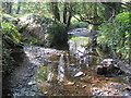
Hartsbourne Stream: Confluence with Oxhey Stream
The main watercourse here is Hartsbourne Stream, viewed looking upstream. Oxhey Stream joins it through the channel to the left. There is of course the mandatory rusting hulk of an old engine (lawnmower?) in the bed.
Image: © Nigel Cox
Taken: 21 Apr 2009
0.16 miles
5
West Coast Main Line passing Sherwoods Wood, South Oxhey
Image: © N Chadwick
Taken: 19 Dec 2010
0.19 miles