IMAGES TAKEN NEAR TO
Cross Road, WATFORD, WD19 4DH
Introduction
This page details the photographs taken nearby to Cross Road, WD19 4DH by members of the Geograph project.
The Geograph project started in 2005 with the aim of publishing, organising and preserving representative images for every square kilometre of Great Britain, Ireland and the Isle of Man.

There are currently over 7.5m images from over14,400 individuals and you can help contribute to the project by visiting https://www.geograph.org.uk
Image Map
Images are licensed for reuse under creativecommons.org/licenses/by-sa/2.0
Notes
- Clicking on the map will re-center to the selected point.
- The higher the marker number, the further away the image location is from the centre of the postcode.
Image Listing (10 Images Found)
Images are licensed for reuse under creativecommons.org/licenses/by-sa/2.0
Image
Details
Distance
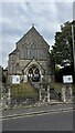
1
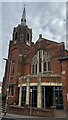
Bushey and Oxhey Methodist Church, Chalk Hill
Image: © Bryn Holmes
Taken: 12 Sep 2023
0.15 miles
2
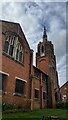
Bushey & Oxhey Methodist Church, Chalk Hill
Image: © Bryn Holmes
Taken: 12 Sep 2023
0.15 miles
3
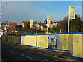
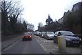
Vale Road, Bushey
A line of bungalows was demolished to make way for this new apartment block development along Vale Road, seen here from its junction with London Road.
Image: © Stephen McKay
Taken: 16 Jan 2016
0.16 miles
4
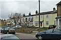
Houses on Villiers Road, Oxhey
A row set back more than the rest of the houses in the road.
Image: © Robin Webster
Taken: 10 Mar 2013
0.17 miles
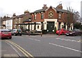
5
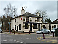
The former (?) Rifle Volunteer
Bereft of name and inn sign, the only clues this is, or was, a pub are its general appearance, street furniture and Courage's cock on the wall.
Image: © Robin Webster
Taken: 10 Mar 2013
0.17 miles
6
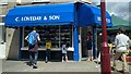
C. Loveday & Son bakery, Villers Road, Oxhey, Watford
Image: © Bryn Holmes
Taken: 11 Jul 2020
0.19 miles
7
Oxhey: The Villiers Arms
Named after the Villiers family who were the Earls of Clarendon, The Villiers Arms is on Villiers Road at its junction with Upper Paddock Road. Although this whole area is now known as Oxhey Village on Victorian Ordnance Survey maps it is described as New Bushey.
Image: © Nigel Cox
Taken: 22 Jan 2012
0.20 miles
8
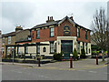
The Villiers Arms, Oxhey
On the corner of Villiers Road and Upper Paddock Road.
Image: © Robin Webster
Taken: 10 Mar 2013
0.20 miles