IMAGES TAKEN NEAR TO
Valley Park, Olds Approach, WATFORD, WD18 9TL
Introduction
This page details the photographs taken nearby to Valley Park, Olds Approach, WD18 9TL by members of the Geograph project.
The Geograph project started in 2005 with the aim of publishing, organising and preserving representative images for every square kilometre of Great Britain, Ireland and the Isle of Man.

There are currently over 7.5m images from over14,400 individuals and you can help contribute to the project by visiting https://www.geograph.org.uk
Image Map
Images are licensed for reuse under creativecommons.org/licenses/by-sa/2.0
Notes
- Clicking on the map will re-center to the selected point.
- The higher the marker number, the further away the image location is from the centre of the postcode.
Image Listing (50 Images Found)
Images are licensed for reuse under creativecommons.org/licenses/by-sa/2.0
Image
Details
Distance
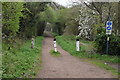
2
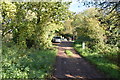
Ebury Way
Unmistakeably a former railway, this was part of the Watford to Rickmansworth branch that has been disused since the 1960s. It now forms part of Ebury Way, a 3.5 mile walking and cycling trail. It was named after Robert Grosvenor, 1st Baron Ebury (1801–1893) who founded the original railway company and was its first chairman.
Image: © Stephen McKay
Taken: 15 Feb 2023
0.05 miles
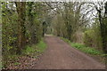
3
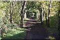
The Ebury Way to the south of Croxley Common Moor
The railway line between Watford and Rickmansworth opened in 1862. Passenger services on the railway line to Rickmansworth (Church Street) ceased in 1952 and most of the branch closed entirely in 1960 although track remained in place for a number of years afterwards. The tracks leading to it continued to be used for goods services until 1967 when it was completely closed and the line cut back to one of the intermediate freight sidings.
A considerable length of the trackbed is now used as the Ebury Way Cycle Path as seen here.
See https://en.wikipedia.org/wiki/Watford_and_Rickmansworth_Railway for more information about the Watford and Rickmansworth Railway.
For further information see http://www.disused-stations.org.uk/r/rickmansworth_church_street/ and https://karenswalks.wordpress.com/2012/01/08/watford-disused-railway-walk-ebury-way-and-the-croxley-green-branch-and-cassiobury-park/
Image: © Marathon
Taken: 22 May 2019
0.05 miles


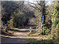
9

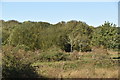
Old's Approach, Tolpits Lane
Part of a sizeable industrial estate, Aspect Gate houses businesses involved in the supply of envelopes and 'packaging solutions'.
Image: © Stephen McKay
Taken: 15 Feb 2023
0.07 miles