IMAGES TAKEN NEAR TO
Cassiobridge Road, WATFORD, WD18 7QL
Introduction
This page details the photographs taken nearby to Cassiobridge Road, WD18 7QL by members of the Geograph project.
The Geograph project started in 2005 with the aim of publishing, organising and preserving representative images for every square kilometre of Great Britain, Ireland and the Isle of Man.

There are currently over 7.5m images from over14,400 individuals and you can help contribute to the project by visiting https://www.geograph.org.uk
Image Map
Images are licensed for reuse under creativecommons.org/licenses/by-sa/2.0
Notes
- Clicking on the map will re-center to the selected point.
- The higher the marker number, the further away the image location is from the centre of the postcode.
Image Listing (79 Images Found)
Images are licensed for reuse under creativecommons.org/licenses/by-sa/2.0
Image
Details
Distance
1
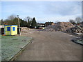
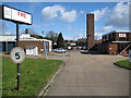
Watford Fire Station (former)
Well, out of all the features shown on Image only the leaning lamppost remained in January 2010! The rest, including the drill tower, have gone. The fire service opened their new Watford fire station in November 2009 here Image and it is planned that this site will be redeveloped to provide about 100 dwellings.
Image: © Nigel Cox
Taken: 31 Jan 2010
0.09 miles
3

Watford fire station
Watford fire station, Whippendell Road, Watford, Hertfordshire
Image: © Kevin Hale
Taken: 12 Nov 2006
0.11 miles
4
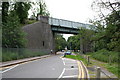
Viaduct of Metropolitan Line over Gade Avenue, Watford
A quiet and select area of the town
Image: © Dr Neil Clifton
Taken: 12 Jun 2007
0.14 miles
5
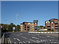
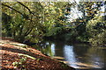
Ascot Road
The junction with Whippendell Road is at the roundabout ahead and just beyond is another roundabout where Ascot Road meets Rickmansworth Road. Turning right at Rickmansworth Road reaches the centre of Watford.
Image: © Marathon
Taken: 18 Sep 2019
0.14 miles
6
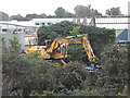
Croxley Rail Link - work in progress
Clearing vegetation from the disused railway line so eventually it can become used again! The road-rail vehicle clearing the plant life is running on the former single line. This picture is taken about 200yards from the photographer's position in Image], from the blue building visible on the left in that picture.
Image: © John Webb
Taken: 11 Sep 2013
0.14 miles
8
Watford Fire Station
This is the Whippendell Road entrance to the fire station with the drill tower to the right. Kevin's Image was taken from around the corner to the left in Rickmansworth Road. The site is being considered for redevelopment with a new fire station being built elsewhere nearer the centre of the town.
Image: © Nigel Cox
Taken: 21 Mar 2008
0.15 miles
9

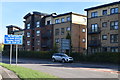
A derelict clock tower
The former clock tower is seen across Ascot Road. Sadly, despite money being used to build the Premier Inn on the left or the Big Yellow Self Storage on the right, no money could be found to restore the clock tower.
Image: © Marathon
Taken: 18 Sep 2019
0.15 miles
10
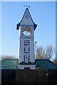
Sun Clock Tower
This curious little clock tower used to stand over an artesian well that supplied water to the long-gone Sun Engraving Company's works. It was built in 1934 to a design by George W. Knight, a principal architect with Stanley Peach & Partners. Despite some restoration work in about 2008 (see Image), it is now in a state of disrepair and is apparently the subject of a dispute between its owners and Watford Borough Council.
Image: © Stephen McKay
Taken: 12 Jan 2022
0.15 miles