IMAGES TAKEN NEAR TO
Cassiobury Park, WATFORD, WD18 7HY
Introduction
This page details the photographs taken nearby to Cassiobury Park, WD18 7HY by members of the Geograph project.
The Geograph project started in 2005 with the aim of publishing, organising and preserving representative images for every square kilometre of Great Britain, Ireland and the Isle of Man.

There are currently over 7.5m images from over14,400 individuals and you can help contribute to the project by visiting https://www.geograph.org.uk
Image Map
Images are licensed for reuse under creativecommons.org/licenses/by-sa/2.0
Notes
- Clicking on the map will re-center to the selected point.
- The higher the marker number, the further away the image location is from the centre of the postcode.
Image Listing (88 Images Found)
Images are licensed for reuse under creativecommons.org/licenses/by-sa/2.0
Image
Details
Distance
1
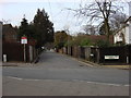
Shepherds Road
Taken from Cassiobury Park Avenue with Cassiobury Park in the background
Image: © Oxyman
Taken: 20 Feb 2009
0.02 miles
2
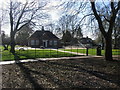
Cassiobury Park
Cha Café Cassiobury Park
Image: © Shaun Ferguson
Taken: 21 Mar 2017
0.02 miles
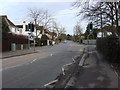
5
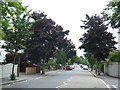
Cassiobury Park Avenue, Watford
Cassiobury Park Avenue is a tree-lined residential road in Watford, Hertfordshire.
Image: © Malc McDonald
Taken: 23 Jun 2012
0.05 miles
7
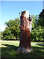
A tree carving in Cassiobury Park
The lands of Cassiobury House belonged to the Earls of Essex for over 300 years. The original lands of Cassiobury House were recorded in an 1837 book as stretching to 693 acres, which included the parkland, the wood walks, lawns and gardens immediately around the house. Today's park comprises 190 acres of those old lands, including the modern day Whipendell Woods. Cassiobury became a public park in 1909. Cassiobury House was subsequently demolished in 1927.
A full history can be seen at https://en.wikipedia.org/wiki/Cassiobury_Park
This carving is not far from the bandstand and the cafe.
Image: © Marathon
Taken: 18 Sep 2019
0.07 miles
8
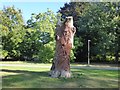
A tree carving in Cassiobury Park
The lands of Cassiobury House belonged to the Earls of Essex for over 300 years. The original lands of Cassiobury House were recorded in an 1837 book as stretching to 693 acres, which included the parkland, the wood walks, lawns and gardens immediately around the house. Today's park comprises 190 acres of those old lands, including the modern day Whipendell Woods. Cassiobury became a public park in 1909. Cassiobury House was subsequently demolished in 1927.
A full history can be seen at https://en.wikipedia.org/wiki/Cassiobury_Park
This carving is not far from the bandstand and the cafe.
Image: © Marathon
Taken: 18 Sep 2019
0.08 miles
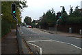
9
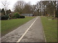
Cycle lane and footpath, Cassiobury Park
There are Basketball courts behind the gray fence.
For more information visit this park's Wikipedia article http://en.wikipedia.org/wiki/Cassiobury_Park
Image: © Oxyman
Taken: 20 Feb 2009
0.08 miles
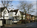
10

Fullerian Crescent, Watford
Fullerian Crescent is a newly-developed road in Watford, Hertfordshire. The road is gated, so that only resdidents and their visitors can enter.
Image: © Malc McDonald
Taken: 23 Jun 2012
0.08 miles