IMAGES TAKEN NEAR TO
WD18 0LP
Introduction
This page details the photographs taken nearby to WD18 0LP by members of the Geograph project.
The Geograph project started in 2005 with the aim of publishing, organising and preserving representative images for every square kilometre of Great Britain, Ireland and the Isle of Man.

There are currently over 7.5m images from over14,400 individuals and you can help contribute to the project by visiting https://www.geograph.org.uk
Image Map
Images are licensed for reuse under creativecommons.org/licenses/by-sa/2.0
Notes
- Clicking on the map will re-center to the selected point.
- The higher the marker number, the further away the image location is from the centre of the postcode.
Image Listing (20 Images Found)
Images are licensed for reuse under creativecommons.org/licenses/by-sa/2.0
Image
Details
Distance
1

Vicarage Road, Watford Football Club
Last day of the season, Watford were already relegated - Coventry hadn't won away in the league all season. Result 1-0 home win.
Image: © Paul Ashwin
Taken: 14 May 2000
0.08 miles
2
Watford Stadium Halt
Back in the days when Watford Football Club were playing in front of large crowds, this halt on the Croxley Green branch line was built to provide access to the Vicarage Road Stadium for away fans. Closed along with the rest of the branch in 1996 the rails remain in place, mothballed presumably in case the long planned Croxley rail link from the Metropolitan Line to the centre of Watford ever gets built. At the time of the submission of the photograph in January 2006, Streetmap http://www.streetmap.co.uk/newmap.srf?x=510190&y=195440&z=1&sv=510190,195440&st=4&ar=Y&mapp=newmap.srf&searchp=newsearch.srf&ax=510190&ay=195440 were helpfully still telling us that the halt was open on match days only...
Image: © Nigel Cox
Taken: 18 Jan 2006
0.12 miles
3
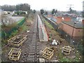
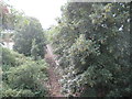
Croxley Rail Link (11): Former Watford Stadium Halt
The trackside vegetation has been cleared in preparation for the development of the link, revealing the former Watford Stadium Halt platform from the Vicarage Road bridge for the first time in many years. Compare with Image from June 2012 and Image from August 2013, and Image from the far end of the platform looking back in this direction from January 2006.
The scheme is now known as the Metropolitan Line Extension.
Image: © Nigel Cox
Taken: 13 Dec 2015
0.12 miles
4
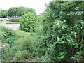
Croxley Rail Link (15): Former Watford Stadium Halt
Five years on from Image] and amidst funding disputes that have caused the project to stall, vegetation is again taking over the station site. The edge of the platform and its old lampposts in faded Network Rail red paint can still be seen.
Image: © Nigel Cox
Taken: 24 Nov 2020
0.12 miles
5
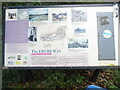
The Ebury Way Information Board near Riverside Park
This information board is at the east end of the Ebury Way track by Riverside Park and has the same wording and photos as the one at the west end at Batchworth, https://www.geograph.org.uk/photo/7033096 refers.
Image: © David Hillas
Taken: 22 Oct 2021
0.13 miles
6
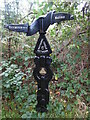
Black Signpost on the Ebury Way near Riverside Park
This black signpost is on the National Cycle Network 6 which runs from London to the Lake District via the East Midlands and Manchester. The left pointer shows 3 miles to Rickmansworth whilst the right pointer shows 1 mile to Watford.
Image: © David Hillas
Taken: 22 Oct 2021
0.14 miles
7
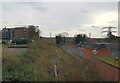
Croxley Rail Link (10): Former L&NWR Croxley Branch
In July 2013 The Secretary of State for Transport issued a Transport and Works Act Order for the proposed Croxley Rail Link scheme granting the planning permissions, access rights and land transfers necessary for the scheme to go ahead. The £118m scheme proposes that the current London Underground Metropolitan Line branch to Watford would be re-routed from a point east of Croxley station and extended to Watford Junction station via Watford High Street station, with the closure of the original Watford station to passenger traffic. It is proposed that new stations would be provided on the new rail link at Ascot Road, where a park and ride facility would be provided, and at Vicarage Road, in order to serve Watford General Hospital, the proposed Watford Health Campus development, and Watford Football Club. Construction work is scheduled to commence in 2014 with completion planned for 2016. The Croxley Rail Link's website is here http://www.croxleyraillink.com/Default.htm
This is a view of the former L&NWR's 1912 built Croxley Branch, the trackbed of which the new line would use, taken from the Vicarage Road bridge. Despite having been closed to traffic in 1996 the railway tracks are still extant here, and over most of the former branch line.
Image: © Nigel Cox
Taken: 4 Aug 2013
0.14 miles
8
Watford Stadium railway station (site), Hertfordshire
Opened in 1982 by British Rail on the line from Watford Junction, this station was only open on match days and closed in 1996.
View south east from Vicarage Road towards Watford High Street and Watford Junction. The railway line and platform were still in situ when this image was taken - just hidden by the undergrowth.
Image: © Nigel Thompson
Taken: 9 Jun 2012
0.14 miles
9

Watford: Ebury Way
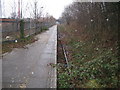
Ebury Way follows the trackbed of the long dismantled railway line from Watford to Rickmansworth. Opened in 1862, it was shortly afterwards taken over by the London & North Western Railway, but was an early victim of the post-war Nationalization of the railways, closing to passenger traffic in 1952. It now forms sections of both National Cycle Network Routes 6 (London to Keswick) and 61 (Rickmansworth to Ware).
Image: © Nigel Cox
Taken: 21 Oct 2008
0.15 miles
10
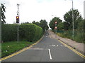
Croxley Rail Link (9): Vicarage Road looking south-west
In July 2013 The Secretary of State for Transport issued a Transport and Works Act Order for the proposed Croxley Rail Link scheme granting the planning permissions, access rights and land transfers necessary for the scheme to go ahead. The £118m scheme proposes that the current London Underground Metropolitan Line branch to Watford would be re-routed from a point east of Croxley station and extended to Watford Junction station via Watford High Street station, with the closure of the original Watford station to passenger traffic. It is proposed that new stations would be provided on the new rail link at Ascot Road, where a park and ride facility would be provided, and at Vicarage Road, in order to serve Watford General Hospital, the proposed Watford Health Campus development, and Watford Football Club. Construction work is scheduled to commence in 2014 with completion planned for 2016. The Croxley Rail Link's website is here http://www.croxleyraillink.com/Default.htm
Vicarage Road would be the site of the proposed new Watford Hospital station on the line. This is the view looking south-westwards towards the bridge carrying the road over the original 1912-built former L&NWR's Croxley Branch, the trackbed of which the new line would use. The main entrance to the new station would on this side of the bridge and to the right.
Image: © Nigel Cox
Taken: 4 Aug 2013
0.17 miles