IMAGES TAKEN NEAR TO
Vicarage Road, WATFORD, WD18 0EJ
Introduction
This page details the photographs taken nearby to Vicarage Road, WD18 0EJ by members of the Geograph project.
The Geograph project started in 2005 with the aim of publishing, organising and preserving representative images for every square kilometre of Great Britain, Ireland and the Isle of Man.

There are currently over 7.5m images from over14,400 individuals and you can help contribute to the project by visiting https://www.geograph.org.uk
Image Map
Images are licensed for reuse under creativecommons.org/licenses/by-sa/2.0
Notes
- Clicking on the map will re-center to the selected point.
- The higher the marker number, the further away the image location is from the centre of the postcode.
Image Listing (117 Images Found)
Images are licensed for reuse under creativecommons.org/licenses/by-sa/2.0
Image
Details
Distance
1
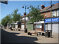
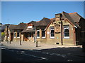
Watford: Vicarage Road Precinct
Collins English Dictionary defines a precinct as an enclosed area or building marked by a fixed boundary such as a wall. Vicarage Road Precinct does not seem to quite fulfil that definition. It is however a long-established pedestrianized section of Vicarage Road, with retail units on either side beneath flats. The buff stone tablet in the brickwork to the right is dated 1881.
Image: © Nigel Cox
Taken: 24 May 2009
0.01 miles
2
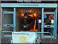
Two Trees Micro, Watford
Located on the pedestrianised part of Vicarage Road near the football ground, the Two Trees Micro is exceptionally small, even by micropub standards. Internally there is a limit of 20 customers. On this day it was celebrating its first birthday and the cake can be seen inside.
Image: © Stephen McKay
Taken: 1 Mar 2023
0.02 miles
3
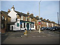
Watford: The Oddfellows and Fearnley Street
The Oddfellows is just around the corner from Vicarage Road Stadium so is a popular location on matchdays. In the fairly recent past it used to be called "Mac's Bar".
Looking at the old Victorian Ordnance Survey map of the area dated 1871-1882 it is evident that these houses and the pub, on the west side of Fearnley Street, were the first to be built in the area and formed an enclave, along with the cemetery to the rear of them, separate from the rest of Watford, and called Colney Butts.
Image: © Nigel Cox
Taken: 3 Apr 2011
0.03 miles
4
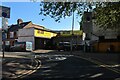
Fit & Go garage on St James Road, Watford
Image: © David Howard
Taken: 30 May 2021
0.04 miles
5
Watford: The former Cottage Hospital
The Cottage Hospital was built in Vicarage Road and opened in 1885 to the designs of the architect C P Ayres. It originally had nine beds, but in 1897, to mark the Diamond Jubilee of Queen Victoria, a new six-bed ward and an operating theatre were added, and finally in 1903 two additional six-bed wards plus dining rooms and staff accommodation were added to bring the capacity to 27 beds. Although all the sandstone tablets are very badly eroded, busts of Queen Victoria and King Edward VII are still discernible in the smaller upper tablets to the right and left respectively, presumably representing the 1897 and 1903 extensions.
The building, which is locally listed, has since been converted into offices and is now known as Victoria House.
Image: © Nigel Cox
Taken: 24 May 2009
0.07 miles
6
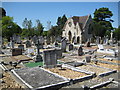
Watford: Vicarage Road Cemetery & Chapel
The Cemetery was opened in 1858 and covers about 5.6 hectares or about 14 acres of land. It is now full for ordinary burials. Although it is now surrounded on three sides by Victorian housing, when it was opened it was in open countryside, away from the centre of Watford in the hamlet of Colney Butts. The original site was rectangular but was extended to the west in late Victorian times before the houses in West Watford were built. This chapel was built as the Episcopal Chapel, there being a separate chapel for Dissenters to the north.
Image: © Nigel Cox
Taken: 24 May 2009
0.08 miles
8
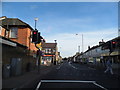
Watford: A4178 Cassio Road
On the right is the former Empire/ABC/Cannon cinema that opened in about 1913 and closed about 1996. The front foyer is now occupied by Izzy's Barbers while the rest of the building is a Muslim community centre. Cassio Road changes to Merton Road at the cinema. This is the view from the top deck of a generally westbound 320 bus, but heading southwards here.
Image: © Nigel Cox
Taken: 25 Apr 2015
0.11 miles
9
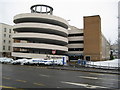
Watford: Church car park, Exchange Road
Church is one of several multi-storey car parks in the town centre, photographed here on a snowy morning.
Image: © Nigel Cox
Taken: 6 Apr 2008
0.12 miles
10
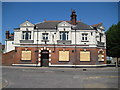
Watford: The Red Lion
The Red Lion is in Vicarage Road and opposite Watford Football Club's stadium. As such it was the home supporters' pub for many years. In fact the Red Lion easily predates the football ground, and the Ordnance Survey map of 1871 shows it, the Union Workhouse and the Cemetery as the main, and indeed virtually the only, features in the hamlet of Colney Butts. The present building dates from 1895 and was designed by the architect C P Ayres. It is locally listed. The text across the front reads:-
THE RED LION BENSKINS CELEBRATED WATFORD ALE & STOUT
The pub was bought by Watford Football Club in 2006 with various intentions of turning it into a club shop, offices and houses, but plans for these were withdrawn late in 2008. In February 2009 Saracens Rugby Club, who share the Vicarage Road stadium with the football club, expressed an interest in taking it over. Currently it stands empty and boarded-up.
Image: © Nigel Cox
Taken: 24 May 2009
0.12 miles