IMAGES TAKEN NEAR TO
Nascot Street, WATFORD, WD17 4RB
Introduction
This page details the photographs taken nearby to Nascot Street, WD17 4RB by members of the Geograph project.
The Geograph project started in 2005 with the aim of publishing, organising and preserving representative images for every square kilometre of Great Britain, Ireland and the Isle of Man.

There are currently over 7.5m images from over14,400 individuals and you can help contribute to the project by visiting https://www.geograph.org.uk
Image Map (Loading...)


Getting Data...Please wait
Leaflet Map data © OpenStreetMap
Images are licensed for reuse under creativecommons.org/licenses/by-sa/2.0
Notes
- Clicking on the map will re-center to the selected point.
- The higher the marker number, the further away the image location is from the centre of the postcode.
Image Listing (100 Images Found)
Images are licensed for reuse under creativecommons.org/licenses/by-sa/2.0
Image
Details
Distance
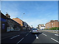
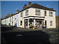
2
Canterbury Road, Watford.
Near the junction of St Albans Road.
Image: © Danny P Robinson
Taken: 5 Sep 2006
0.06 miles

4
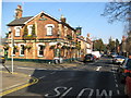
Watford: Nascot Arms public house
On Stamford Road at the corner of Nascot Place, the pub dates from 1869 and is contemporary with the Victorian housing development in the area. The pub is a Greene King house and the inn sign features Watford Council's coat of arms with the word 'audentior'. This comes from the Latin phrase 'Tu ne cede malis, sed contra audentior ito, quam tua te fortuna sinet', which roughly translates into 'Yield not to misfortunes, but advance all the more boldly against them'.
The distant church is Image Spot the cat!
Image: © Nigel Cox
Taken: 16 Feb 2008
0.08 miles
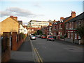
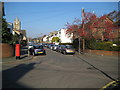
5
Westland Road Watford
Looking towards Station Road (the station being Watford Junction).
Image: © Danny P Robinson
Taken: 5 Sep 2006
0.11 miles
6
Watford: Langley Hardware, 32 Langley Road
In these days of dominance by a few large d-i-y chain stores it is heartening to see that the traditional hardware store is still thriving. On display outside the shop today there is a mop head for every occasion, brushes, all sorts of shapes and sizes of galvanized dustbins, even a zinc bath! So, good people of Watford, get down there today and support your local store!
Image: © Nigel Cox
Taken: 16 Feb 2008
0.12 miles
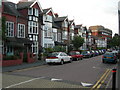
7
Watford: Church Road
The church is Image, visible on the left.
Image: © Nigel Cox
Taken: 16 Feb 2008
0.14 miles
8

Watford: The Flag public house
This attractive building was originally the Clarendon Hotel, built in Station Road in 1860 to serve travellers using the nearby Watford Junction railway station. A comparison with a drawing of the building made in 1862 shows that little has changed in the intervening 146 years! It eventually became a Benskins public house known as The Pennant, but subsequently was rebranded as The Flag and Firkin, finally dropping the Firkin name. For some time the forecourt outside the building, to the left, was used as the bus terminus for the railway station. The building to the left formerly housed the hotel's stables. The building is Grade II listed.
Image: © Nigel Cox
Taken: 16 Feb 2008
0.15 miles
9
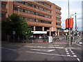
Watford Junction Railway Station
Watford Junction is a through station on the Euston Mainline which runs approximately northwest/southeast through the station. It is also the terminus of the Silverlink Metro line from Euston (southeast), the South Central service to Gatwick Airport (southeast) and the Watford Junction - St Albans Abbey line (northwest).
Image: © Chris Hunt
Taken: 3 Jul 2005
0.15 miles
10
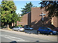
Watford: St Thomas' United Reformed Church
The church is in Langley Road.
The United Reformed Church was formed as the result of a union between the Presbyterian Church of England and the Congregational Church in England and Wales in 1972, and subsequent unions with the Reformed Association of Churches of Christ in 1981 and the Congregational Union of Scotland in 2000.
Image: © Nigel Cox
Taken: 21 Sep 2008
0.16 miles