IMAGES TAKEN NEAR TO
Greenbank Road, WATFORD, WD17 4FJ
Introduction
This page details the photographs taken nearby to Greenbank Road, WD17 4FJ by members of the Geograph project.
The Geograph project started in 2005 with the aim of publishing, organising and preserving representative images for every square kilometre of Great Britain, Ireland and the Isle of Man.

There are currently over 7.5m images from over14,400 individuals and you can help contribute to the project by visiting https://www.geograph.org.uk
Image Map
Images are licensed for reuse under creativecommons.org/licenses/by-sa/2.0
Notes
- Clicking on the map will re-center to the selected point.
- The higher the marker number, the further away the image location is from the centre of the postcode.
Image Listing (17 Images Found)
Images are licensed for reuse under creativecommons.org/licenses/by-sa/2.0
Image
Details
Distance
1
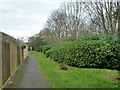
Path and green area between housing and A41
A long strip of green insulates the housing here from some of the noise of the busy A41 in a cutting to the right.
Image: © Robin Webster
Taken: 1 Feb 2015
0.11 miles
2
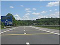
M25 slip road approaches Hunton Bridge roundabout
The blanked out third lane on the right is a legacy of the slip road acting as the temporary main line of the M25 between 1976 and 1986, with major traffic flows at the roundabout onto the A405 and A41.
Image: © Peter Whatley
Taken: 19 Jun 2012
0.16 miles
3
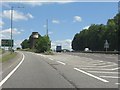
Leavesden exit, A405
The exit to the magical world of Harry Potter! A ventilation shaft for the Watford Fast Lines Tunnel features between the two roads.
Image: © Peter Whatley
Taken: 19 Jun 2012
0.16 miles
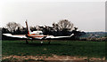
4

Leavesden Aerodrome
Aircraft parked outside the hangars at the southwestern end of the airfield. These hangars were mainly used for aircraft parking and minor maintenance. A radio maintenance and supply company had offices inside - these are visible through the open doors above the white Beech 200 aircraft. The closest aircraft is a Piper PA-23 Aztec used for traffic information flights on behalf of LBC. This airfield is now disused.
Image: © Martin Addison
Taken: 26 Nov 1989
0.16 miles
5
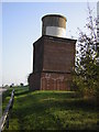
Ventilation Shaft for Watford North Rail Tunnel
This shaft is located between the exit slip and the main carriageway of the A41 east of Hunton Bridge roundabout. A plaque indicates that the lower section brickwork was added in 1997, presumably when the road alterations exposed the original underground brickwork.
Image: © jonny davy
Taken: 23 Oct 2007
0.17 miles
6
M25 from Leavesden Aerodrome
Looking from the grass parking area opposite the Hangars in the southwestern corner of the airfield. The section of M25 visible in the photo is the Watford stub from junction 19. Hidden behind the trees and at a lower level than the airfield is the large roundabout where it connects with the A41 and the A411. This airfield is now disused.
Image: © Martin Addison
Taken: 26 Nov 1989
0.19 miles
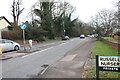
9
Hempstead Road at the corner of Russells Nursery
Image: © David Howard
Taken: 2 Feb 2022
0.21 miles
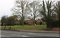
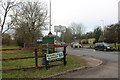
10
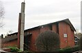
The Church of Jesus Christ and the Latter Day Saints, Watford
Image: © David Howard
Taken: 2 Feb 2022
0.22 miles