IMAGES TAKEN NEAR TO
The Gardens, WATFORD, WD17 3LN
Introduction
This page details the photographs taken nearby to The Gardens, WD17 3LN by members of the Geograph project.
The Geograph project started in 2005 with the aim of publishing, organising and preserving representative images for every square kilometre of Great Britain, Ireland and the Isle of Man.

There are currently over 7.5m images from over14,400 individuals and you can help contribute to the project by visiting https://www.geograph.org.uk
Image Map (Loading...)


Getting Data...Please wait
Leaflet Map data © OpenStreetMap
Images are licensed for reuse under creativecommons.org/licenses/by-sa/2.0
Notes
- Clicking on the map will re-center to the selected point.
- The higher the marker number, the further away the image location is from the centre of the postcode.
Image Listing (26 Images Found)
Images are licensed for reuse under creativecommons.org/licenses/by-sa/2.0
Image
Details
Distance
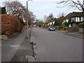
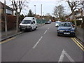
2
Watford: Cassiobury Drive
Cassiobury Drive is the main road through the Cassiobury Estate, which was developed for housing in the parkland of the former Cassiobury House. The Cassiobury Estate was originally owned by the Earls of Essex, but, after the death of the 6th Earl in 1892, it was gradually sold off on a piecemeal basis during the early 20th century, Cassiobury House itself being finally demolished in 1927.
This view of Cassiobury Drive, looking towards Watford town centre, was taken at the junction with The Gardens on the briefly snowy morning of 6 April 2008.
Image: © Nigel Cox
Taken: 6 Apr 2008
0.02 miles
4
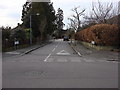
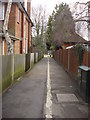
Temple Close
The signs at either side of the entrance to this road state "Temple Close leading to Cottage Close"
Image: © Oxyman
Taken: 20 Feb 2009
0.07 miles
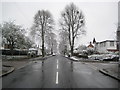
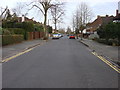
5
The Gardens
Part of Cassiobury Estate with Image visible on the left
Image: © Oxyman
Taken: 20 Feb 2009
0.09 miles
6
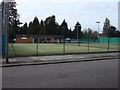
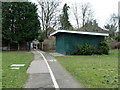
Cassiobury Tennis Club
This club's website http://www.cassioburytennis.org.uk/
Image: © Oxyman
Taken: 20 Feb 2009
0.10 miles
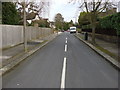
8
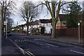
Cassiobury Drive, Watford
Seen from the junction with Stratford Way, Cassiobury Drive is part of a residential estate on land that was once part of the Earls of Essex's country estate. The land was sold with a covenant that only good quality detached and semi-detached houses could be built and the area remains a desirable one to this day.
Image: © Stephen McKay
Taken: 30 Jan 2016
0.15 miles
9
A way out of Cassiobury Park
To Parkside Drive.
Image: © Robin Webster
Taken: 10 Mar 2013
0.15 miles
10
Alley between Parkside Drive and Cassiobury Park
Image: © Oxyman
Taken: 20 Feb 2009
0.15 miles