IMAGES TAKEN NEAR TO
Parkside Drive, WATFORD, WD17 3BB
Introduction
This page details the photographs taken nearby to Parkside Drive, WD17 3BB by members of the Geograph project.
The Geograph project started in 2005 with the aim of publishing, organising and preserving representative images for every square kilometre of Great Britain, Ireland and the Isle of Man.

There are currently over 7.5m images from over14,400 individuals and you can help contribute to the project by visiting https://www.geograph.org.uk
Image Map (Loading...)


Getting Data...Please wait
Leaflet Map data © OpenStreetMap
Images are licensed for reuse under creativecommons.org/licenses/by-sa/2.0
Notes
- Clicking on the map will re-center to the selected point.
- The higher the marker number, the further away the image location is from the centre of the postcode.
Image Listing (43 Images Found)
Images are licensed for reuse under creativecommons.org/licenses/by-sa/2.0
Image
Details
Distance
2
Cassiobury Park
Part of the park near the paddling pools.
Image: © Stephen McKay
Taken: 30 Jan 2016
0.10 miles
3
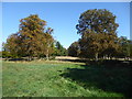
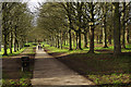
The beginning of autumn in Cassiobury Park
This is close to the main path through Cassiobury Park. It is mid September but after a long, dry and warm summer with record temperatures and the warm days continuing well into September, some of the trees are starting to turn.
The lands of Cassiobury House belonged to the Earls of Essex for over 300 years. The original lands of Cassiobury House were recorded in an 1837 book as stretching to 693 acres, which included the parkland, the wood walks, lawns and gardens immediately around the house. Today's park comprises 190 acres of those old lands, including the modern day Whipendell Woods. Cassiobury became a public park in 1909. Cassiobury House was subsequently demolished in 1927.
A full history can be seen at https://en.wikipedia.org/wiki/Cassiobury_Park
Image: © Marathon
Taken: 18 Sep 2019
0.10 miles
4
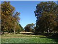
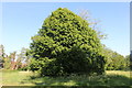
First signs of Autumn in Cassiobury Park
This is close to the main path through Cassiobury Park. It is mid September but after a long, dry and warm summer with record temperatures and the warm days continuing well into September, some of the trees are starting to turn.
The lands of Cassiobury House belonged to the Earls of Essex for over 300 years. The original lands of Cassiobury House were recorded in an 1837 book as stretching to 693 acres, which included the parkland, the wood walks, lawns and gardens immediately around the house. Today's park comprises 190 acres of those old lands, including the modern day Whipendell Woods. Cassiobury became a public park in 1909. Cassiobury House was subsequently demolished in 1927.
A full history can be seen at https://en.wikipedia.org/wiki/Cassiobury_Park
Image: © Marathon
Taken: 18 Sep 2019
0.11 miles
5
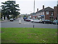
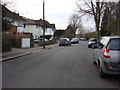
Watford: Cassiobury Estate
Once belonging to the Earls of Essex, the Estate was gradually sold off for housing development, and eventually Cassiobury House itself was demolished in 1927. This is a view looking north-eastwards up Langley Way from the roundabout at the junction with Cassiobury Drive.
Image: © Nigel Cox
Taken: 11 Oct 2005
0.12 miles
6
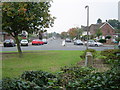
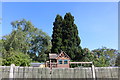
Watford: Cassiobury Estate
Once belonging to the Earls of Essex, the Estate was gradually sold off for housing development, and eventually Cassiobury House itself was demolished in 1927. This is a view looking south-eastwards down Cassiobury Drive from the roundabout at the junction with Langley Way.
Image: © Nigel Cox
Taken: 11 Oct 2005
0.12 miles
7
Cassiobury Park
Looking down towards the paddling pools where the path bends to the left and continues to the River Gade.
Image: © Stephen McKay
Taken: 30 Jan 2016
0.12 miles
8
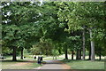
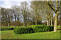
Path through avenue of trees, Cassiobury Park
Image: © David Martin
Taken: 27 Jun 2022
0.12 miles