IMAGES TAKEN NEAR TO
High Street, WATFORD, WD17 2BU
Introduction
This page details the photographs taken nearby to High Street, WD17 2BU by members of the Geograph project.
The Geograph project started in 2005 with the aim of publishing, organising and preserving representative images for every square kilometre of Great Britain, Ireland and the Isle of Man.

There are currently over 7.5m images from over14,400 individuals and you can help contribute to the project by visiting https://www.geograph.org.uk
Image Map (Loading...)


Getting Data...Please wait
Leaflet Map data © OpenStreetMap
Images are licensed for reuse under creativecommons.org/licenses/by-sa/2.0
Notes
- Clicking on the map will re-center to the selected point.
- The higher the marker number, the further away the image location is from the centre of the postcode.
Image Listing (204 Images Found)
Images are licensed for reuse under creativecommons.org/licenses/by-sa/2.0
Image
Details
Distance
1
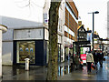
High Street / New Street
Shows the location of Image
Image: © Mike Quinn
Taken: 15 Jan 2020
0.00 miles
2
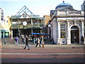
Watford: Charter Place & the HSBC bank
A contrast in building styles at the entrance to Charter Place from the High Street. Charter Place houses Watford Market, and the Royal Charter to hold a market here dates from 1100. Watford Market's website can be found here http://www.watfordmarket.co.uk/wm_index2.html
Image: © Nigel Cox
Taken: 28 Jan 2006
0.00 miles
3
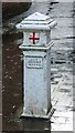
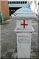
Coal tax boundary post no.47, New Street / High Street
The location of this post is shown in Image, Image, Image and Image
This post was originally located about three quarters of a mile to the southeast on the north side of Lower High Street by the Bushey Arches; it was moved in 1968. It has been set very low into the ground; these posts usually have part or all of their black base showing - see for example Image
There were originally nearly 280 coal tax posts located around London, of which about 210 are still extant; around 180 of these (85%) are 3 ft high white-painted square bollards with a pyramidal top, decorative raised bands, and the shield from the City of London’s arms, like this one. Photos of the coal tax posts on Geograph are at http://www.geograph.org.uk/search.php?i=86542993&page=1 .
The posts were erected under the Coal and Wine Duties (Continuation) Act of 1861 to mark the points at which duty had to be paid on coal being transported to London. The boundary was set at that of the Metropolitan Police District, and the resulting revenue was used by the Corporation of the City of London to fund public works. For further info see http://www.coaldutyposts.org.uk/cityposts.html .
Image: © Mike Quinn
Taken: 15 Jan 2020
0.01 miles
4
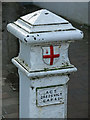
Coal tax boundary post no.47, New Street / High Street - detail
See Image and Image This post is one of 14 with extant correction plates (13 of which are of the same type as this one).
Image: © Mike Quinn
Taken: 15 Jan 2020
0.01 miles
5
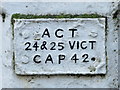
Coal tax boundary post no.47, New Street / High Street - correction plate
Image: © Mike Quinn
Taken: 15 Jan 2020
0.01 miles
6
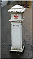
Coal tax boundary post no.48, New Street / Church Street
The location of this post is shown in Image and Image
This post was originally located almost a mile to the southeast on the south side of Capel Road at its junction with Pinner Road; it was moved in 1968. It has been set quite low into the ground; these posts usually have a larger part of their black base showing - see for example Image
There were originally nearly 280 coal tax posts located around London, of which about 210 are still extant; around 180 of these (85%) are 3 ft high white-painted square bollards with a pyramidal top, decorative raised bands, and the shield from the City of London’s arms, like this one. Photos of the coal tax posts on Geograph are at http://www.geograph.org.uk/search.php?i=86542993&page=1 .
The posts were erected under the Coal and Wine Duties (Continuation) Act of 1861 to mark the points at which duty had to be paid on coal being transported to London. The boundary was set at that of the Metropolitan Police District, and the resulting revenue was used by the Corporation of the City of London to fund public works. For further info see http://www.coaldutyposts.org.uk/cityposts.html .
Image: © Mike Quinn
Taken: 15 Jan 2020
0.01 miles
7
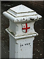
Coal tax boundary post no.48, New Street / Church Street - detail
Image: © Mike Quinn
Taken: 15 Jan 2020
0.01 miles
8
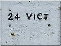
Coal tax boundary post no.48, New Street / Church Street - inscription
See Image The missing correction plate reveals that the original inscription was "24 VICT". Posts with this inscription were cast in 1861, but before the 1861 Act was passed, and hence before the full regnal year and chapter number were known. See also Image
Image: © Mike Quinn
Taken: 15 Jan 2020
0.01 miles
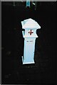
9
Old Boundary Marker on Watford High Street
Coal Tax Marker on the southwest side of Watford High Street in the centre of the pedestrianised New Street. For the history of these markers read http://www.coaldutyposts.org.uk/cityposts.html. This is Martin Nail’s No. 47
Milestone Society National ID: HE_CTWAT02bm
Image: © R Westcott
Taken: Unknown
0.02 miles
10
Old Boundary Marker on New Street, Watford
Coal Tax Marker at the point where New Street ceases to be a service road and becomes a pedestrian walkway to Watford High Street. For the history of these markers read http://www.coaldutyposts.org.uk/cityposts.html. This is Martin Nail’s No. 48
Milestone Society National ID: HE_CTWAT03bm
Image: © C Woodward
Taken: Unknown
0.02 miles